 FAO Map Catalog
Adaptive Capacity
Type of resources
Available actions
Topics
Keywords
Provided by
Formats
Representation types
Update frequencies
status
-

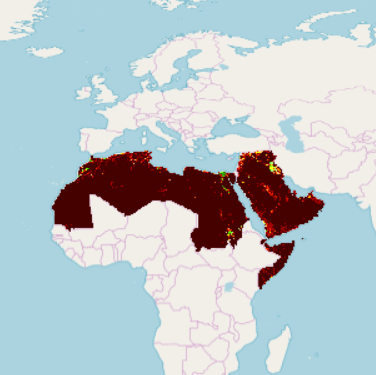
Part of the Integrated Vulnerability Assessment in the Arab Region, this 1km pixel resolution raster dataset provides a representation Vulnerability Assessment Output - Adaptive Capacity, in the Middle East and North Africa Region. Vulnerability is a concept used to express the complex interaction of climate change effects and the susceptibility of a system to its impacts. The integrated vulnerability assessment methodology is based on an understanding of vulnerability as a function of a system’s climate change exposure, sensitivity and adaptive capacity to cope with climate change effects, consistent with the approach put forward by the Intergovernmental Panel on Climate Change (IPCC) in its Fourth Assessment Report (AR4). Combining exposure, sensitivity and adaptive capacity allows assessing the vulnerability of a system to climate change. The integrated vulnerability assessment combines a series of single vulnerability assessments for several water-related climate change impacts on different sectors. Adaptive capacity Indicators were assumed to retain the same values for the reference period and future periods, and raster grid pixel values were classified according to level of Adaptive Capacity, from low 1 to high 10.
-

Part of the Integrated Vulnerability Assessment in the Arab Region, this 1km pixel resolution raster dataset provides a representation of Adaptive Capacity to climate change, for Infrastructure dimension indicator - Water and Sanitation - Access to Improved Sanitation - in the Middle East and North Africa Region. Vulnerability is a concept used to express the complex interaction of climate change effects and the susceptibility of a system to its impacts. The integrated vulnerability assessment methodology is based on an understanding of vulnerability as a function of a system’s climate change exposure, sensitivity and adaptive capacity to cope with climate change effects, consistent with the approach put forward by the Intergovernmental Panel on Climate Change (IPCC) in its Fourth Assessment Report (AR4). Combining exposure, sensitivity and adaptive capacity allows assessing the vulnerability of a system to climate change. Within this conceptual framework, Adaptive Capacity refers to “the ability of a system to adjust to climate change (including climate variability and extremes), to moderate potential damages, to take advantage of opportunities, or to cope with the consequences” as defined in the IPCC AR4. The Adaptive Capacity Infrastructure dimension can be considered as ability mechanisms whereby they characterize the accessibility to the built environment as a means to adapt. Indicators were selected based on five pillars: energy, transportation, health, water and sanitation, and environment, were assumed to retain the same values for the reference period and future periods, and raster grid pixel values classified according to level of Adaptive Capacity, from low 1 to high 10.
-
Part of the Integrated Vulnerability Assessment in the Arab Region, this 1km pixel resolution raster dataset provides a representation of Adaptive Capacity to climate change, for Infrastructure dimension indicator - Water and Sanitation - Areas Served by Dams - in the Middle East and North Africa Region. Vulnerability is a concept used to express the complex interaction of climate change effects and the susceptibility of a system to its impacts. The integrated vulnerability assessment methodology is based on an understanding of vulnerability as a function of a system’s climate change exposure, sensitivity and adaptive capacity to cope with climate change effects, consistent with the approach put forward by the Intergovernmental Panel on Climate Change (IPCC) in its Fourth Assessment Report (AR4). Combining exposure, sensitivity and adaptive capacity allows assessing the vulnerability of a system to climate change. Within this conceptual framework, Adaptive Capacity refers to “the ability of a system to adjust to climate change (including climate variability and extremes), to moderate potential damages, to take advantage of opportunities, or to cope with the consequences” as defined in the IPCC AR4. The Adaptive Capacity Infrastructure dimension can be considered as ability mechanisms whereby they characterize the accessibility to the built environment as a means to adapt. Indicators were selected based on five pillars: energy, transportation, health, water and sanitation, and environment, were assumed to retain the same values for the reference period and future periods, and raster grid pixel values classified according to level of Adaptive Capacity, from low 1 to high 10.
-

Part of the Integrated Vulnerability Assessment in the Arab Region, this 1km pixel resolution raster dataset provides a representation of the Adaptive Capacity to climate change, for the Institutions dimension indicator - Governance Index - in the Middle East and North Africa Region. Vulnerability is a concept used to express the complex interaction of climate change effects and the susceptibility of a system to its impacts. The integrated vulnerability assessment methodology is based on an understanding of vulnerability as a function of a system’s climate change exposure, sensitivity and adaptive capacity to cope with climate change effects, consistent with the approach put forward by the Intergovernmental Panel on Climate Change (IPCC) in its Fourth Assessment Report (AR4). Combining exposure, sensitivity and adaptive capacity allows assessing the vulnerability of a system to climate change. Within this conceptual framework, Adaptive Capacity refers to “the ability of a system to adjust to climate change (including climate variability and extremes), to moderate potential damages, to take advantage of opportunities, or to cope with the consequences” as defined in the IPCC AR4. Adaptive Capacity was categorized into six dimensions, the Institutions dimension can be classified as action devices that describe the enabling environment that allow a society to adapt. The indicator is assumed to retain the same values for the reference period and future periods, and the raster grid was classified according to level of Adaptive Capacity, from low 1 to high 10.
-

Part of the Integrated Vulnerability Assessment in the Arab Region, this 1km pixel resolution raster dataset provides a representation of Adaptive Capacity to climate change, for Equity dimension indicator - Migrants-Refugees Index - in the Middle East and North Africa Region. Vulnerability is a concept used to express the complex interaction of climate change effects and the susceptibility of a system to its impacts. The integrated vulnerability assessment methodology is based on an understanding of vulnerability as a function of a system’s climate change exposure, sensitivity and adaptive capacity to cope with climate change effects, consistent with the approach put forward by the Intergovernmental Panel on Climate Change (IPCC) in its Fourth Assessment Report (AR4). Combining exposure, sensitivity and adaptive capacity allows assessing the vulnerability of a system to climate change. Within this conceptual framework, Adaptive Capacity refers to “the ability of a system to adjust to climate change (including climate variability and extremes), to moderate potential damages, to take advantage of opportunities, or to cope with the consequences” as defined in the IPCC AR4. Adaptive Capacity Equity dimension/category considers vulnerable population groups which can be based on gender, socio-economic status, or marginalization. The Indicator was assumed to retain the same values for the reference period and future periods, and raster grid pixel values were classified according to level of Adaptive Capacity, from low 1 to high 10.
-

Part of the Integrated Vulnerability Assessment in the Arab Region, this 1km pixel resolution raster dataset provides a representation of Adaptive Capacity to climate change, for Energy - Access to Electricity - indicator, in the Middle East and North Africa Region. Vulnerability is a concept used to express the complex interaction of climate change effects and the susceptibility of a system to its impacts. The integrated vulnerability assessment methodology is based on an understanding of vulnerability as a function of a system’s climate change exposure, sensitivity and adaptive capacity to cope with climate change effects, consistent with the approach put forward by the Intergovernmental Panel on Climate Change (IPCC) in its Fourth Assessment Report (AR4). Combining exposure, sensitivity and adaptive capacity allows assessing the vulnerability of a system to climate change. Within this conceptual framework, Adaptive Capacity refers to “the ability of a system to adjust to climate change (including climate variability and extremes), to moderate potential damages, to take advantage of opportunities, or to cope with the consequences” as defined in the IPCC AR4. The Adaptive Capacity Infrastructure dimension can be considered as ability mechanisms whereby they characterize the accessibility to the built environment as a means to adapt. Indicators were selected based on five pillars: energy, transportation, health, water and sanitation, and environment, were assumed to retain the same values for the reference period and future periods, and raster grid pixel values classified according to level of Adaptive Capacity, from low 1 to high 10.
-
Part of the Integrated Vulnerability Assessment in the Arab Region, this 1km pixel resolution raster dataset provides a representation of the Adaptive Capacity to climate change, for the Institutions dimension indicator - Areas Under Nature Protection - in the Middle East and North Africa Region. Vulnerability is a concept used to express the complex interaction of climate change effects and the susceptibility of a system to its impacts. The integrated vulnerability assessment methodology is based on an understanding of vulnerability as a function of a system’s climate change exposure, sensitivity and adaptive capacity to cope with climate change effects, consistent with the approach put forward by the Intergovernmental Panel on Climate Change (IPCC) in its Fourth Assessment Report (AR4). Combining exposure, sensitivity and adaptive capacity allows assessing the vulnerability of a system to climate change. Within this conceptual framework, Adaptive Capacity refers to “the ability of a system to adjust to climate change (including climate variability and extremes), to moderate potential damages, to take advantage of opportunities, or to cope with the consequences” as defined in the IPCC AR4. Adaptive Capacity was categorized into six dimensions, the Institutions dimension can be classified as action devices that describe the enabling environment that allow a society to adapt. The indicator is assumed to retain the same values for the reference period and future periods, and the raster grid was classified according to level of Adaptive Capacity, from low 1 to high 10.
-

Part of the Integrated Vulnerability Assessment in the Arab Region, this 1km pixel resolution raster dataset provides a representation of Adaptive Capacity to climate change, for Transportation - Density of Road Network - in the Middle East and North Africa Region. Vulnerability is a concept used to express the complex interaction of climate change effects and the susceptibility of a system to its impacts. The integrated vulnerability assessment methodology is based on an understanding of vulnerability as a function of a system’s climate change exposure, sensitivity and adaptive capacity to cope with climate change effects, consistent with the approach put forward by the Intergovernmental Panel on Climate Change (IPCC) in its Fourth Assessment Report (AR4). Combining exposure, sensitivity and adaptive capacity allows assessing the vulnerability of a system to climate change. Within this conceptual framework, Adaptive Capacity refers to “the ability of a system to adjust to climate change (including climate variability and extremes), to moderate potential damages, to take advantage of opportunities, or to cope with the consequences” as defined in the IPCC AR4. The Adaptive Capacity Infrastructure dimension can be considered as ability mechanisms whereby they characterize the accessibility to the built environment as a means to adapt. Indicators were selected based on five pillars: energy, transportation, health, water and sanitation, and environment, were assumed to retain the same values for the reference period and future periods, and raster grid pixel values classified according to level of Adaptive Capacity, from low 1 to high 10.
-

Part of the Integrated Vulnerability Assessment in the Arab Region, this 1km pixel resolution raster dataset provides a representation of Adaptive Capacity to climate change, for Infrastructure dimension indicator - Water and Sanitation - Areas Equipped for Irrigation - in the Middle East and North Africa Region. Vulnerability is a concept used to express the complex interaction of climate change effects and the susceptibility of a system to its impacts. The integrated vulnerability assessment methodology is based on an understanding of vulnerability as a function of a system’s climate change exposure, sensitivity and adaptive capacity to cope with climate change effects, consistent with the approach put forward by the Intergovernmental Panel on Climate Change (IPCC) in its Fourth Assessment Report (AR4). Combining exposure, sensitivity and adaptive capacity allows assessing the vulnerability of a system to climate change. Within this conceptual framework, Adaptive Capacity refers to “the ability of a system to adjust to climate change (including climate variability and extremes), to moderate potential damages, to take advantage of opportunities, or to cope with the consequences” as defined in the IPCC AR4. The Adaptive Capacity Infrastructure dimension can be considered as ability mechanisms whereby they characterize the accessibility to the built environment as a means to adapt. Indicators were selected based on five pillars: energy, transportation, health, water and sanitation, and environment, were assumed to retain the same values for the reference period and future periods, and raster grid pixel values were classified according to level of Adaptive Capacity, from low 1 to high 10.
-

Part of the Integrated Vulnerability Assessment in the Arab Region, this 1km pixel resolution raster dataset provides a representation of Adaptive Capacity to climate change, for Infrastructure dimension indicator - Water and Sanitation - Desalination Capacity - in the Middle East and North Africa Region. Vulnerability is a concept used to express the complex interaction of climate change effects and the susceptibility of a system to its impacts. The integrated vulnerability assessment methodology is based on an understanding of vulnerability as a function of a system’s climate change exposure, sensitivity and adaptive capacity to cope with climate change effects, consistent with the approach put forward by the Intergovernmental Panel on Climate Change (IPCC) in its Fourth Assessment Report (AR4). Combining exposure, sensitivity and adaptive capacity allows assessing the vulnerability of a system to climate change. Within this conceptual framework, Adaptive Capacity refers to “the ability of a system to adjust to climate change (including climate variability and extremes), to moderate potential damages, to take advantage of opportunities, or to cope with the consequences” as defined in the IPCC AR4. The Adaptive Capacity Infrastructure dimension can be considered as ability mechanisms whereby they characterize the accessibility to the built environment as a means to adapt. Indicators were selected based on five pillars: energy, transportation, health, water and sanitation, and environment, were assumed to retain the same values for the reference period and future periods, and raster grid pixel values classified according to level of Adaptive Capacity, from low 1 to high 10.