 FAO Map Catalog
AQUAMAPS_rivers
Type of resources
Available actions
Topics
Keywords
Contact for the resource
Provided by
Years
Formats
Representation types
Update frequencies
status
Scale
-

The rivers of Europe dataset is derived from the World Wildlife Fund's (WWF) HydroSHEDS drainage direction layer and a stream network layer. The source of the drainage direction layer was the 15-second Digital Elevation Model (DEM) from NASA's Shuttle Radar Topographic Mission (SRTM). The raster stream network was determined by using the HydroSHEDS flow accumulation grid, with a threshold of about 1000 km² upstream area. The stream network dataset consists of the following information: the origin node of each arc in the network (FROM_NODE), the destination of each arc in the network (TO_NODE), the Strahler stream order of each arc in the network (STRAHLER), numerical code and name of the major basin that the arc falls within (MAJ_BAS and MAJ_NAME); - area of the major basin in square km that the arc falls within (MAJ_AREA); - numerical code and name of the sub-basin that the arc falls within (SUB_BAS and SUB_NAME); - area of the sub-basin in square km that the arc falls within (SUB_AREA); - numerical code of the sub-basin towards which the sub-basin flows that the arc falls within (TO_SUBBAS) (the codes -888 and -999 have been assigned respectively to internal sub-basins and to sub-basins draining into the sea). The attributes table now includes a field named "Regime" with tentative classification of perennial ("P") and intermittent ("I") streams.
-
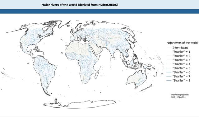
This dataset is derived from the World Wildlife Fund's (WWF) HydroSHEDS drainage direction layer and a stream network layer. The source of the drainage direction layer was the 15-second Digital Elevation Model (DEM) from NASA's Shuttle Radar Topographic Mission (SRTM). The raster stream network was determined by using the HydroSHEDS flow accumulation grid, with a threshold of about 1000 km² upstream area. The stream network dataset consists of the following information: the origin node of each arc in the network (FROM_NODE), the destination of each arc in the network (TO_NODE), the Strahler stream order of each arc in the network (STRAHLER), numerical code and name of the major basin that the arc falls within (MAJ_BAS and MAJ_NAME); - area of the major basin in square km that the arc falls within (MAJ_AREA); - numerical code and name of the sub-basin that the arc falls within (SUB_BAS and SUB_NAME); - area of the sub-basin in square km that the arc falls within (SUB_AREA); - numerical code of the sub-basin towards which the sub-basin flows that the arc falls within (TO_SUBBAS) (the codes -888 and -999 have been assigned respectively to internal sub-basins and to sub-basins draining into the sea). The attributes table now includes a field named "Regime" with tentative classification of perennial ("P") and intermittent ("I") streams.
-
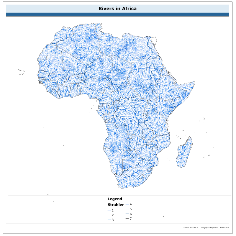
The rivers of Africa dataset is derived from the World Wildlife Fund's (WWF) HydroSHEDS drainage direction layer and a stream network layer. The source of the drainage direction layer was the 15-second Digital Elevation Model (DEM) from NASA's Shuttle Radar Topographic Mission (SRTM). The raster stream network was determined by using the HydroSHEDS flow accumulation grid, with a threshold of about 1000 km² upstream area. The stream network dataset consists of the following information: the origin node of each arc in the network (FROM_NODE), the destination of each arc in the network (TO_NODE), the Strahler stream order of each arc in the network (STRAHLER), numerical code and name of the major basin that the arc falls within (MAJ_BAS and MAJ_NAME); - area of the major basin in square km that the arc falls within (MAJ_AREA); - numerical code and name of the sub-basin that the arc falls within (SUB_BAS and SUB_NAME); - area of the sub-basin in square km that the arc falls within (SUB_AREA); - numerical code of the sub-basin towards which the sub-basin flows that the arc falls within (TO_SUBBAS) (the codes -888 and -999 have been assigned respectively to internal sub-basins and to sub-basins draining into the sea). The attributes table now includes a field named "Regime" with tentative classification of perennial ("P") and intermittent ("I") streams.
-
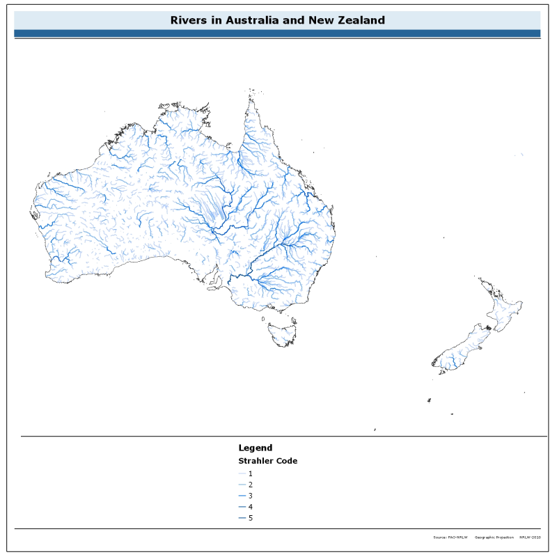
The rivers of Australia and New Zealand dataset is derived from the World Wildlife Fund's (WWF) HydroSHEDS drainage direction layer and a stream network layer. The source of the drainage direction layer was the 15-second Digital Elevation Model (DEM) from NASA's Shuttle Radar Topographic Mission (SRTM). The raster stream network was determined by using the HydroSHEDS flow accumulation grid, with a threshold of about 1000 km² upstream area. The stream network dataset consists of the following information: the origin node of each arc in the network (FROM_NODE), the destination of each arc in the network (TO_NODE), the Strahler stream order of each arc in the network (STRAHLER), numerical code and name of the major basin that the arc falls within (MAJ_BAS and MAJ_NAME); - area of the major basin in square km that the arc falls within (MAJ_AREA); - numerical code and name of the sub-basin that the arc falls within (SUB_BAS and SUB_NAME); - area of the sub-basin in square km that the arc falls within (SUB_AREA); - numerical code of the sub-basin towards which the sub-basin flows that the arc falls within (TO_SUBBAS) (the codes -888 and -999 have been assigned respectively to internal sub-basins and to sub-basins draining into the sea). The attributes table now includes a field named "Regime" with tentative classification of perennial ("P") and intermittent ("I") streams.
-
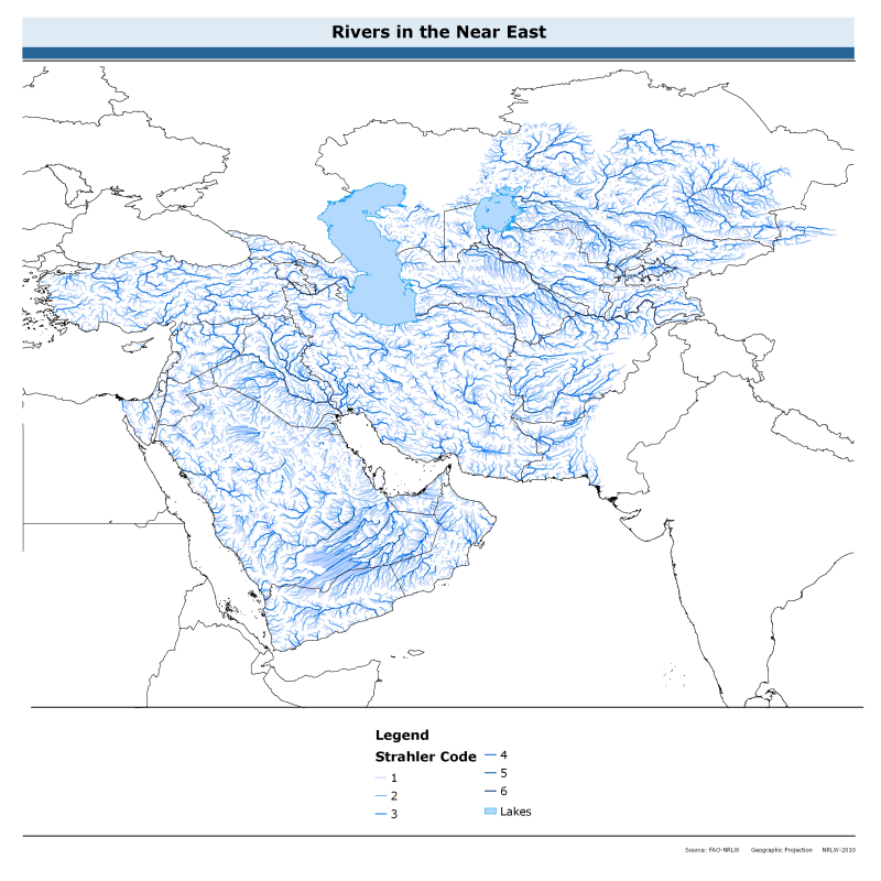
The rivers of the Near East dataset is derived from the World Wildlife Fund's (WWF) HydroSHEDS drainage direction layer and a stream network layer. The source of the drainage direction layer was the 15-second Digital Elevation Model (DEM) from NASA's Shuttle Radar Topographic Mission (SRTM). The raster stream network was determined by using the HydroSHEDS flow accumulation grid, with a threshold of about 1000 km² upstream area. The stream network dataset consists of the following information: the origin node of each arc in the network (FROM_NODE), the destination of each arc in the network (TO_NODE), the Strahler stream order of each arc in the network (STRAHLER), numerical code and name of the major basin that the arc falls within (MAJ_BAS and MAJ_NAME); - area of the major basin in square km that the arc falls within (MAJ_AREA); - numerical code and name of the sub-basin that the arc falls within (SUB_BAS and SUB_NAME); - area of the sub-basin in square km that the arc falls within (SUB_AREA); - numerical code of the sub-basin towards which the sub-basin flows that the arc falls within (TO_SUBBAS) (the codes -888 and -999 have been assigned respectively to internal sub-basins and to sub-basins draining into the sea). The attributes table now includes a field named "Regime" with tentative classification of perennial ("P") and intermittent ("I") streams.
-

The rivers of Central America dataset is derived from the World Wildlife Fund's (WWF) HydroSHEDS drainage direction layer and a stream network layer. The source of the drainage direction layer was the 15-second Digital Elevation Model (DEM) from NASA's Shuttle Radar Topographic Mission (SRTM). The raster stream network was determined by using the HydroSHEDS flow accumulation grid, with a threshold of about 1000 km² upstream area. The stream network dataset consists of the following information: the origin node of each arc in the network (FROM_NODE), the destination of each arc in the network (TO_NODE), the Strahler stream order of each arc in the network (STRAHLER), numerical code and name of the major basin that the arc falls within (MAJ_BAS and MAJ_NAME); - area of the major basin in square km that the arc falls within (MAJ_AREA); - numerical code and name of the sub-basin that the arc falls within (SUB_BAS and SUB_NAME); - area of the sub-basin in square km that the arc falls within (SUB_AREA); - numerical code of the sub-basin towards which the sub-basin flows that the arc falls within (TO_SUBBAS) (the codes -888 and -999 have been assigned respectively to internal sub-basins and to sub-basins draining into the sea). The attributes table now includes a field named "Regime" with tentative classification of perennial ("P") and intermittent ("I") streams.
-
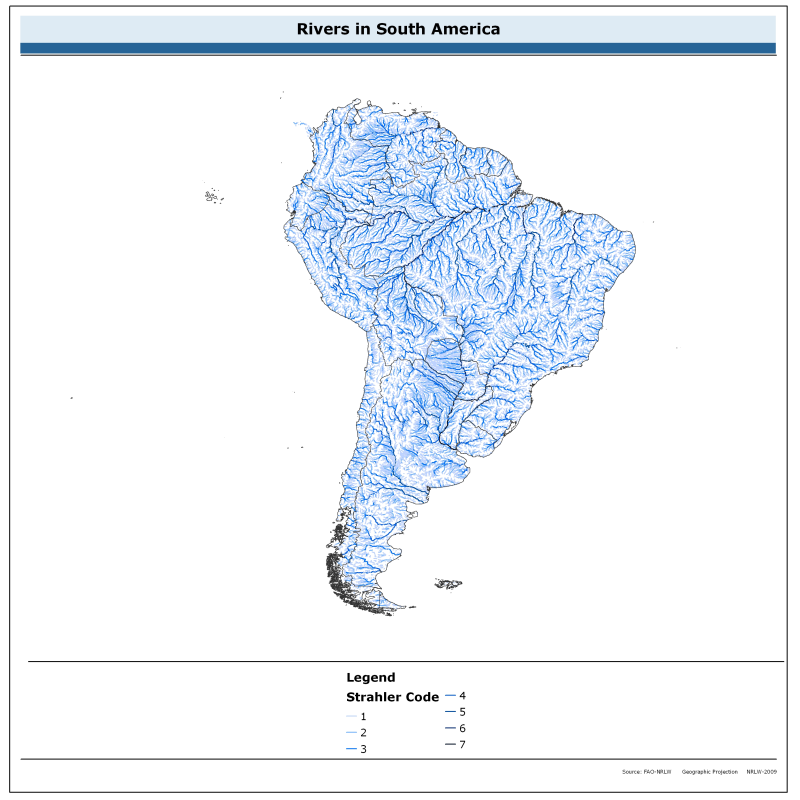
The rivers of South America are derived from the World Wildlife Fund's (WWF) HydroSHEDS drainage direction layer and a stream network layer.The drainage direction layer was created from NASA's Shuttle Radar Topographic Mission (SRTM) 15-second Digital Elevation Model (DEM).The raster stream network was determined by using the HydroSHEDS flow accumulation grid, with a threshold of about 100 km² upstream area. The stream network dataset consists of the following information: the origin node of each arc in the network (FROM_NODE), the destination of each arc in the network (TO_NODE), the Strahler stream order of each arc in the network (STRAHLER), numerical code and name of the major basin that the arc falls within (MAJ_BAS and MAJ_NAME); - area of the major basin in square km that the arc falls within (MAJ_AREA); - numerical code and name of the sub-basin that the arc falls within (SUB_BAS and SUB_NAME); - area of the sub-basin in square km that the arc falls within (SUB_AREA); - numerical code of the sub-basin towards which the sub-basin flows that the arc falls within (TO_SUBBAS) (the codes -888 and -999 have been assigned respectively to internal sub-basins and to sub-basins draining into the sea). The attributes table now includes a field named "Regime" with tentative classification of perennial ("P") and intermittent ("I") streams.
-
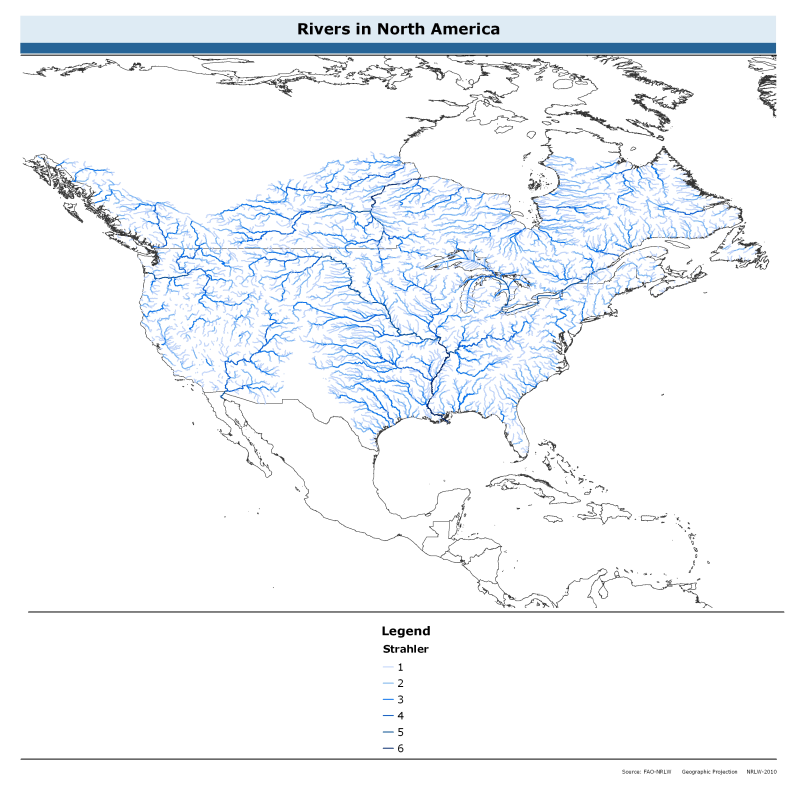
The rivers of North America dataset is derived from the World Wildlife Fund's (WWF) HydroSHEDS drainage direction layer and a stream network layer. The source of the drainage direction layer was the 15-second Digital Elevation Model (DEM) from NASA's Shuttle Radar Topographic Mission (SRTM). The raster stream network was determined by using the HydroSHEDS flow accumulation grid, with a threshold of about 1000 km² upstream area. The stream network dataset consists of the following information:- unique arc identifier (ARCID), the origin node of each arc in the network (FROM_NODE), the destination of each arc in the network (TO_NODE), the Strahler stream order of each arc in the network (STRAHLER), numerical code and name of the major basin that the arc falls within (MAJ_BAS and MAJ_NAME); - area of the major basin in square km that the arc falls within (MAJ_AREA); - numerical code and name of the sub-basin that the arc falls within (SUB_BAS and SUB_NAME); - area of the sub-basin in square km that the arc falls within (SUB_AREA); - numerical code of the sub-basin towards which the sub-basin flows that the arc falls within (TO_SUBBAS) (the codes -888 and -999 have been assigned respectively to internal sub-basins and to sub-basins draining into the sea).
-
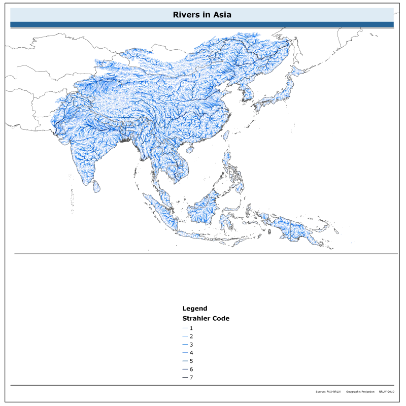
The rivers of South and East Asia dataset is derived from the World Wildlife Fund's (WWF) HydroSHEDS drainage direction layer and a stream network layer. The source of the drainage direction layer was the 15-second Digital Elevation Model (DEM) from NASA's Shuttle Radar Topographic Mission (SRTM). The raster stream network was determined by using the HydroSHEDS flow accumulation grid, with a threshold of about 1000 km² upstream area. The stream network dataset consists of the following information: the origin node of each arc in the network (FROM_NODE), the destination of each arc in the network (TO_NODE), the Strahler stream order of each arc in the network (STRAHLER), numerical code and name of the major basin that the arc falls within (MAJ_BAS and MAJ_NAME); - area of the major basin in square km that the arc falls within (MAJ_AREA); - numerical code and name of the sub-basin that the arc falls within (SUB_BAS and SUB_NAME); - area of the sub-basin in square km that the arc falls within (SUB_AREA); - numerical code of the sub-basin towards which the sub-basin flows that the arc falls within (TO_SUBBAS) (the codes -888 and -999 have been assigned respectively to internal sub-basins and to sub-basins draining into the sea). The attributes table now includes a field named "Regime" with tentative classification of perennial ("P") and intermittent ("I") streams.
-
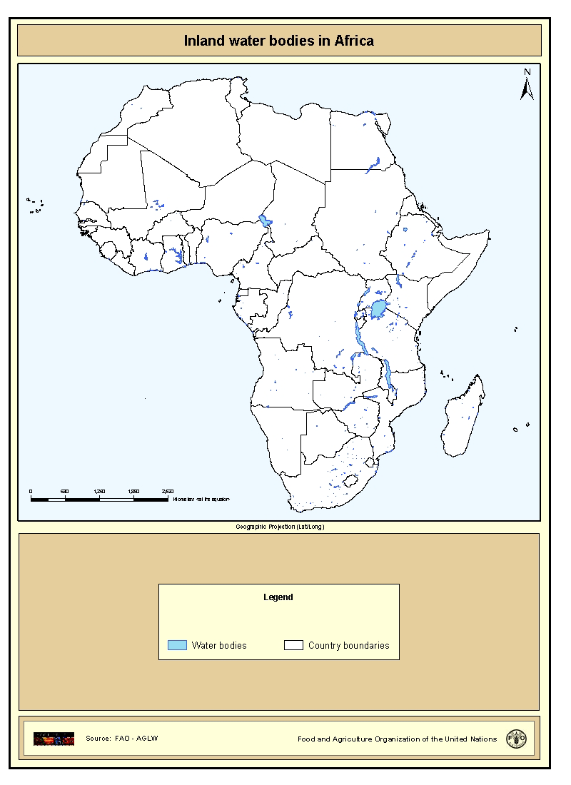
Shapefile of inland water bodies in Africa. This dataset originates from the Digital Chart of the World 1:1000000, 1998. The waterbodies for Africa have been characterized (as lake, lagoon, reservoir etc.) and named (if the names were easily available). The data layer presented contains all the waterbodies that had a name and were not characterized as river.