 FAO Map Catalog
850000
Type of resources
Available actions
Topics
Keywords
Contact for the resource
Provided by
Years
Representation types
Update frequencies
status
Scale
-
Grayscale hillshaded image of SRTM 3 as terrestrial DEM and ETopo2 bathymetric data, resampled for compatibility with HydroShed data for Africa. SRTM is Shuttle Radar Topography Mission; DEM is Digital Elevation Model; ETopo2 is a 2 minute Elevation Topographic DEM including bathymetry. The 7-5AS_GSCL_SRTM-BATH image data layer is comprised of 37221x45583 derivative image hillshade features derived based on 0.0020833333_ data originally from SRTM 3as v.2.
-
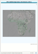
ETM+ Browse based cartographic reference, resampled and 2.5d enhanced using SRTM 3 as DEM to provide visual and map output reference for HydroShed data of Africa. SRTM is Shuttle Radar Topography Mission; DEM is Digital Elevation Model;. The AF_ETM-SHD image data layer is comprised of 37221x45583 derivative image satellite based imagery features derived based on 0.0020833333_ data originally from ETM+ Browse.
-
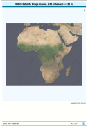
2nd generation NASA Blue Marble image base, resampled and 2.5d enhanced using SRTM 3 as DEM to provide visual and map output reference for HydroShed data of Africa. SRTM is Shuttle Radar Topography Mission; DEM is Digital Elevation Model.. The AF_BMNG-SHD image data layer is comprised of 37221x45583 derivative image satellite based imagery features derived based on 0.0020833333_ data originally from MODIS BlueMarble-2.