 FAO Map Catalog
70000000
Type of resources
Available actions
Topics
Keywords
Contact for the resource
Provided by
Years
Representation types
Update frequencies
status
Scale
-
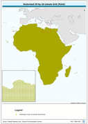
Vectorized 10-by-10 minute Grid (Point). The CRU_PT shapefile data layer is comprised of 92718 derivative calculated climate features derived based on 0.167 degrees resolution data originally from CRU. The layer provides nominal analytical/mapping at 1:70 000 000. Acronyms and Abbreviations: CRU - Climatic Research Unit - School of Environmental Sciences, University of East Anglia - Norwich.
-
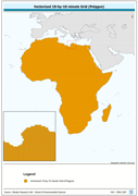
Vectorized 10-by-10 minute Grid (Polygon). The CRU_PY shapefile data layer is comprised of 92718 derivative calculated climate features derived based on 0.167 degrees resolution data originally from CRU. The layer provides nominal analytical/mapping at 1:70 000 000. Acronyms and Abbreviations: CRU - Climatic Research Unit - School of Environmental Sciences, University of East Anglia - Norwich.
-
Consolidated Table of CRU Evapotranspiration. The ET_MNTHY tabular data layer is comprised of 92717 derivative raster evapotranspiration features derived based on 0.16667_ data originally from CRU. The layer provides nominal analytical/mapping at 1:70 000 000. Acronyms and Abbreviations: CRU - Climatic Research Unit - School of Environmental Sciences, University of East Anglia - Norwich.
-
Consolidated Table of CRU Precipitation.. The RF_MNTHY tabular data layer is comprised of 92715 derivative raster precipitation features derived based on 0.16667_ data originally from CRU. The layer provides nominal analytical/mapping at 1:70 000 000. Acronyms and Abbreviations: CRU - Climatic Research Unit - School of Environmental Sciences, University of East Anglia - Norwich.
-
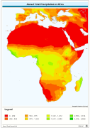
Annual Total Precipitation. The PRCP_YR grid data layer is comprised of 1080x2160 derivative raster precipitation features derived based on 0.167 degrees resolution data originally from CRU. Monthly precipitation from January to December is also available for download. Acronyms and Abbreviations: CRU - Climatic Research Unit - School of Environmental Sciences, University of East Anglia - Norwich.