 FAO Map Catalog
125000
Type of resources
Available actions
Topics
Keywords
Contact for the resource
Provided by
Years
Representation types
Update frequencies
status
Scale
-

SWB and related hydrological features subset of the AfriCover country separates. The Africover shapefile data layer is comprised of 11296 derivative vector land cover - africover features derived based on ~1:250 000 data originally from FAO. The layer provides nominal analytical/mapping at 1:125 000. Acronyms and Abbreviations: SWB - Surface Water Body.
-
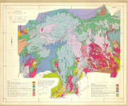
Include: Soil reconnaissance; Land suitability map (2 sheets)
-
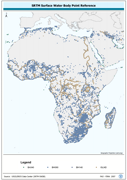
Centroid point locations of SWB, Double-Lined River and inshore island features. The SWBD_PT shapefile data layer is comprised of 38840 derivative vector surface water bodies features derived based on 1:100 000 data originally from SRTM-SWBD. The layer provides nominal analytical/mapping at 1:125 000. Data processing 60% complete globally, with African and Arabian subsets 100% complete. Acronyms and Abbreviations: SWB or SWBD - Surface Water Body; SRTM - Shuttle Radar Topography Mission.
-

Detailed reconnaissance soil survey, Southwest Johore Coconut area
-
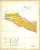
Include: Soil reconnaissance map (3 sheets) Soil reconnaissance map -land suitability map (3 sheets b&w)
-
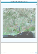
Enhanced natural color and 2.5d hillshade orthorectified image derivative, reprojected and mosaiced into single coverage of a Megabasin. Source: NASA Landsat Orthorectified MSS, TM and ETM+. The VOLTA_TM-SHD image data layer is comprised of 42465x46324 derivative image satellite based imagery features derived based on 28.5 metre data originally from TM.
-
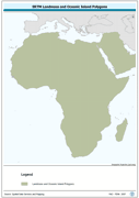
Seamless polygonal continental landmass and oceanic island mask data layer derived from SRTM-SWBD tiled database. The MASK_PY shapefile data layer is comprised of 4333 derivative vector surface water bodies features derived based on 1:100 000 data originally from SRTM-SWBD. The layer provides nominal analytical/mapping at 1:125 000. Data processing 60% complete globally, with African and Arabian subsets 100% complete. Acronyms and Abbreviations: SRTM - Shuttle Radar Topography Mission; SWBD - Surface water Body.
-
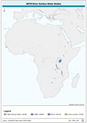
Seamless and robust derivative of SWB, Double-Lined River, and Inshore Island Features from SRTM-SWBD data tiles. The SWBD_PY shapefile data layer is comprised of 38840 derivative vector surface water bodies features derived based on 1:100 000 data originally from SRTM-SWBD. The layer provides nominal analytical/mapping at 1:125 000. Data processing 60% complete globally, with African and Arabian subsets 100% complete. Acronyms and Abbreviations: SWB or SWBD - Surface Water Body; SRTM - Shuttle Radar Topography Mission.
-

Linear representation of SWB, Double-Lined River, and Inshore Island Features. The SWBD_LN shapefile data layer is comprised of 54741 derivative vector surface water bodies features derived based on 1:100 000 data originally from SRTM-SWBD. The layer provides nominal analytical/mapping at 1:125 000. Data processing 60% complete globally, with African and Arabian subsets 100% complete. Acronyms and Abbreviations: SWB or SWBD - Surface Water Body; SRTM - Shuttle Radar Topography Mission.
-
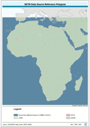
Polygonal seamless representation of SRTM Digital Elevation Model source reference. The SRC_PY shapefile data layer is comprised of 7536 derivative vector surface water bodies features derived based on 1:100 000 data originally from SRTM-SWBD. The layer provides nominal analytical/mapping at 1:125 000. Data processing 60% complete globally, with African and Arabian subsets 100% complete. Acronyms and Abbreviations: DEM - Digital Elevation Model; SRTM - Shuttle Radar Topography Mission.