 FAO Map Catalog
1998
Type of resources
Available actions
Topics
Keywords
Contact for the resource
Provided by
Years
Formats
Representation types
Update frequencies
status
Scale
-
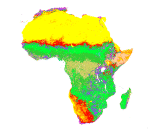
Land cover map based on the International Geosphere Biosphere Programme (IGBP) classification scheme.
-
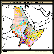
The SEA (Soil and Terrain Database Map of East Africa) is a Digital Soil Map at 1:1000000 scale for the following countries: Burundi, Djibouti, Egypt, Eritrea, Ethiopia, Kenya, Somalia, Sudan, Rwanda, and Uganda. Compilation of the SEA was subcontracted to ISRIC (Netherlands) by FAO in 1988. The main purpose, at that time, was to test the validity of the 1988 revision of the FAO/Unesco legend for the Soil Map of the World at 1:1 million scale. In 1990, the maps and the related tabular databases were automated (converted into digital form), in the FAO Geographic Information System Centre. The final version as been completed and made available in CD-ROM since 1998.
-
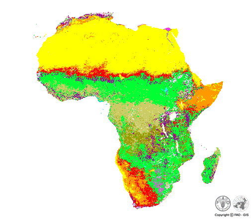
Land cover map based on the U.S. Geological Survey (USGS) classification scheme.
-

Cropwatch is China's leading agricultural monitoring system, using remote sensing and ground observation data to assess crop growth, yield and related information on national and global scales. The Cropwatch scientific team is affiliated to the Aerospace Information Research Institute (AIR) under the Chinese Academy of Sciences (CAS) since 1998. The CropWatch Cloud (http://cloud.cropwatch.com.cn) is a crop-monitoring platform developed to give users access to recent Earth observation data and innovative crop monitoring technology . The open and shared cloud-based agricultural production information services (APIS) reduces the food market volatility, in line with the community of shared future for mankind. CropWatch Cloud also upgrades current satellite data downloading to real-time processing and analyses. CropWatch Cloud provides an open and customizable APIS that stakeholders over the world can calibrate, localize, customize and automatically generate agro-climatic and agronomic indicators according to their own specific requirements (area, phenology, and crop) in areas of their interest. Taking advantages of cloud storage and cloud computing capacity, developing countries and stakeholders over the world can independently carry out crop monitoring and make their own analyses, at various scales from subnational to global, in areas of their interest on the CropWatch Cloud, without additional investments on hardware and software, which are the main constrains that prevent developing countries from building up their crop monitoring capacity. CropWatch Cloud provides real-time or near real-time APIS and food security early warning through releasing quarterly CropWatch Bulletins including information on agro-climatic situations, natural disasters, crop conditions, crop yield and production at global, regional, national and sub-national levels. CropWatch Cloud allows stakeholders to carry out collaborative information analyses to improve the credibility and transparency of agricultural production information, which is essential for ironing the speculations on the world food market. CropWatch Bulletins have been downloaded by stakeholders from more than 160 countries and regions around the world and the CropWatch Cloud platform recognized as a valuable tool for supporting developing countries in the implementation of the sustainable development goals (SDGs), in particular SDGs 2 - Zero Hunger.