 FAO Map Catalog
15-0
Type of resources
Available actions
Topics
Keywords
Contact for the resource
Provided by
Years
Representation types
Update frequencies
status
Scale
-
Enhanced natural color and 2.5d hillshade orthorectified image derivative. The LKTAN_IMGCAT_IMGSHD image data layer is comprised of 120 derivative calculated seamless image catalog features derived based on 15 metre data originally from FAO.
-
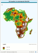
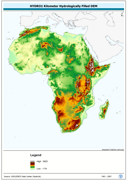
WRIA_DEM: Hydrologically filled GTopo30 DEM with the main stems of cartographic rivers "burned-in" for irrigation analysis. GT30/GTopo30 is Global Topographic 30 arc second DEM database, nominal 1km postings; DEM is Digital Elevation Model. The WRIALAEA grid data layer is comprised of 9194x8736 derivative raster hydrologically filled dem features derived based on 1 kilometer data originally from FAO.
-
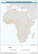
Ad1-Seamless and topologically robust derivative of all polygonal VMap0 - Ed5 coastline and national/sovereign boundary data layers cross-checked against related linear vectors. The AD1_PY shapefile data layer is comprised of 1122 derivative vector framework library features derived based on 1:1 000 000 data originally from VMap0, 5th Edition. The layer provides nominal analytical/mapping at 1:1 000 000. Data processing complete globally, this is an African subset. Acronyms and Abbreviations: VMap0 - Vector Map for Level 0.
-
Enhanced natural color orthorectified image baseline. The LKTAN_IMGCAT_IMG image data layer is comprised of 120 derivative calculated seamless image catalog features derived based on 28 metre data originally from FAO.
-
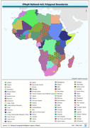
Ad2-Seamless and topologically robust derivative of all polygonal VMap0 - Ed5 coastal, national, subnational and sovereign boundary data layers cross-checked against related linear vectors. The AD2_PY shapefile data layer is comprised of 1753 derivative vector framework library features based on data from VMap0, 5th Edition. The layer provides analytical/mapping at 1:1 000 000. Data processing complete globally, this is an African subset. Acronyms and Abbreviations: VMap0 - Vector Map for Level 0.
-
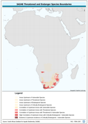
Threatened to endangered species watershed boundaries based SAIAB and HYDRO1k. Source: SAIAB and HYDRO1k, "river" flow, and watershed networks based on the GTopo30. The AQSP_THRTND_PY shapefile data layer is comprised of 92 derivative polygon aquatic species features derived based on 1:2 000 000 data originally from SAIAB. The layer provides nominal analytical/mapping at 1:2 000 000. Acronyms and Abbreviations: SAIAB - South African Institute for Aquatic Biodiversity; HYDRO1k - Global Hydrological 1 kilometre database of hydrologically filled DEMs; DEM - Digital Elevation Model; GT30/GTopo30 - Global Topographic 30 arc second DEM database, nominal 1km postings.
-
An hydrologically filled version of the GTopo30 DEM employing a Afro-centric Lambert Azimuthal Equal Area Projection. The H1K_LAEA grid data layer is comprised of 9194x8736 derivative raster hydrologically filled dem features derived based on 1 kilometer data originally from HYDRO1k. Acronyms and Abbreviations: GT30/GTopo30 - Global Topographic 30 arc second DEM database, nominal 1km postings; DEM - Digital Elevation Model.