 FAO Map Catalog
10-0
Type of resources
Available actions
Topics
Keywords
Contact for the resource
Provided by
Years
Representation types
Update frequencies
status
Scale
-
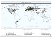
Linear railway layer consolidated from 2 separate source data layers. The RWDB_RR shapefile data layer is comprised of 25407 derivative vector framework library features derived based on 1:3 000 000 data originally from RWDBII. The layer provides nominal analytical/mapping at 1:3 000 000. Data processing complete globally. Acronyms and Abbreviations: RWDB2 or RWDB II- Relational World Database II.
-
Consolidated table of air temperature. The AT_MNTHY tabular data layer is comprised of 1004351 derivative raster air temperature features derived based on 0.5_ data originally from CRES/FAO. The layer provides nominal analytical/mapping at 1:220 000 000. Acronyms and Abbreviations: CRES - Centre for Resource and Environmental Studies, The Australian National University (ANU); FAO - Food and Agriculture Organization in the United Nations.
-
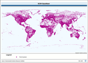
Consolidated Table of 7 Year Short Average Decadal Rainfall. The RFE_SAVG tabular data layer is comprised of 471688 derivative raster precipitation features derived based on 8 kilometers data originally from EDC. The layer provides nominal analytical/mapping at 1:3 500 000. Acronyms and Abbreviations: EDC - USGS EROS (Earth Resources Observation Systems) Data Center.
-
Linear roads layer consolidated from 3 separate source data layers. The RWDB_RD shapefile data layer is comprised of 72099 derivative vector framework library features derived based on 1:3 000 000 data originally from RWDBII. The layer provides nominal analytical/mapping at 1:3 000 000. Data processing complete globally. Acronyms and Abbreviations: RWDB2 or RWDB II- Relational World Database II.
-
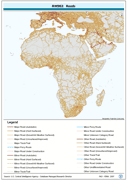
Full Digital Chart of the world Gazetteer database. The DCW_GZTR shapefile data layer is comprised of 151739 derivative point gazetteer and annotation features derived based on 1:1 000 000 data originally from DCW. The layer provides nominal analytical/mapping at 1:1 000 000. Data processing is complete globally, this is an African subset. Acronyms and Abbreviations: DCW - Digital Chart of the World.