 FAO Map Catalog
society
Type of resources
Available actions
Topics
Keywords
Contact for the resource
Provided by
Years
Formats
Representation types
Update frequencies
status
Scale
Resolution
-

As part of the the World Bank's review of its rural development strategy, the Bank sought the assistance of the Food and Agriculture Organization of the United Nations (FAO) in evaluating how farming systems might change and adapt over the next thirty years. Amongst other objectives, the World Bank asked FAO to provide guidance on priorities for investment in food security, poverty reduction, and economic growth, and in particular to identify promising approaches and technologies that will contribute to these goals. The results of the study are summarized in a set of seven documents, comprising six regional reports and the global overview contained in this volume. This document, which synthesises the results of the six regional analyses as well as discussing global trends, cross-cutting issues and possible implementation modalities, presents an overview of the complete study. This document is supplemented by two case study reports of development issues of importance to farming systems globally.
-
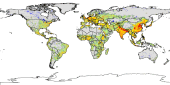
The Food and Agriculture Organization of the United Nations (FAO) with the collaboration of the International Institute for Applied Systems Analysis (IIASA), has developed a system that enables rational land-use planning on the basis of an inventory of land resources and evaluation of biophysical limitations and potentials. This is referred to as the Agro-ecological Zones (AEZ) methodology.
-
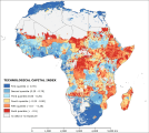
The “technological capital index” symbolizes the physical means that determine the potential adaptive capacity degree of a particular unit of analysis in 2010. It is linked with the diffusion of basic life technology and infrastructure (e.g. transportation network). It is the combination of two underlying indexes: the “household technology index” and the “infrastructure index”. These original indexes correspond to the two principal components recognized by Principal Component Analysis among 10 potential variables. The analysis assigned relative weights to the “household technology index” and the “infrastructure index”, that are 0.62 and 0.38, respectively. This dataset has been produced in the framework of the “Climate change predictions in Sub-Saharan Africa: impacts and adaptations (ClimAfrica)” project, Work Package 4 (WP4). More information on ClimAfrica project is provided in the Supplemental Information section of this metadata.
-
The FGGD high-resolution urban population distribution map is a global raster datalayer with a resolution of 30 arc-seconds. Each pixel classified as urban by the urban area boundaries map contains a numeric count of persons in the land area represented by the pixel. All remaining pixels contain a negative value. The method used by FAO to generate this datalayer is described in FAO, 2006, Mapping global urban and rural population distributions, by M. Salvatore, et. al.
-

This data set depicts the distribution of marginal areas by administrative zones in Santiago, Cape Verde, according to a Marginality Index methodology. The Marginality Index measures the incidence of food insecurity and poverty (FIP) among the households living in each area. The index is created as a function of the most relevant variables of the year 2000 Demographic Census, using the principal components methodology. Areas with an index score above a selected threshold level have been classified as vulnerable. The boundaries of administrative zones were digitized from scanned and rectified topographic maps (Carta Militar de Portugal, Ilha de Santiago 1969).
-

The “institutional capital index” relates to the management means that determine the potential adaptive capacity degree of a particular governance institution in 2010. It is linked with the governance capacity and behavior, the tendency to conflict and the ability to manage environmental issue of a certain governmental institution. It is the combination of three underlying indexes: the “governance index”, “conflictuality index” and the “environmental management index”. These original indexes correspond to the three principal components identified by Principal Component Analysis among 18 potential variables. The analysis assigned the relative weights of 0.6 , 0.3 and 0.1 for the “governance index”, “conflictuality index” and the “environmental management index”, respectively. This dataset has been produced in the framework of the “Climate change predictions in Sub-Saharan Africa: impacts and adaptations (ClimAfrica)” project, Work Package 4 (WP4). More information on ClimAfrica project is provided in the Supplemental Information section of this metadata.
-
The FGGD high resolution rural population density map is a global raster datalayer with a resolution of 30 arc-seconds. Each pixel classified as rural by the urban area boundaries map contains the number of persons per square kilometre. All remaining pixels contain no data. The method used by FAO to generate this datalayer is described in FAO, 2006, Mapping global urban and rural population distributions, by M. Salvatore, et. al.
-
The FGGD high resolution rural settlements population distribution map is a global raster datalayer with a resolution of 30 arc-seconds. Each pixel classified as rural by the urban area boundaries map but having a population density value of 2000 or above, contains a numeric count of persons in the land area represented by the pixel. All remaining pixels contain a negative value. The method used by FAO to generate this datalayer is described in FAO, 2006, Mapping global urban and rural population distributions, by M. Salvatore, et. al.
-
The FGGD high-resolution urban population density map is a global raster datalayer with a resolution of 30 arc-seconds. Each pixel classified as urban by the urban area boundaries map contains the number of persons per square kilometre. All remaining pixels contain no data. The method used by FAO to generate this datalayer is described in FAO, 2006, Mapping global urban and rural population distributions, by M. Salvatore, et. al.