 FAO Map Catalog
U.S. Central Intelligence Agency - Database Manager/Research Director
Type of resources
Available actions
Topics
Keywords
Contact for the resource
Provided by
Years
Representation types
Update frequencies
status
Scale
-
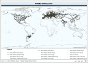
Linear railway layer consolidated from 2 separate source data layers. The RWDB_RR shapefile data layer is comprised of 25407 derivative vector framework library features derived based on 1:3 000 000 data originally from RWDBII. The layer provides nominal analytical/mapping at 1:3 000 000. Data processing complete globally. Acronyms and Abbreviations: RWDB2 or RWDB II- Relational World Database II.
-

Enhanced Rivers linear derivative based on 4 separate RWDB2 Library layers. The RWDB_RIV shapefile data layer is comprised of 4376 derivative line framework library features derived based on 1:3 000 000 data originally from . The layer provides nominal analytical/mapping at 1:3 000 000. Data processing is complete globally, this is an African subset. Acronyms and Abbreviations: RWDB2 or RWDB II- Relational World Database II.
-

Point based representation of populated place with encoding differentiating national and subnational capitals and other related administrative centres. The RWDB_PPL shapefile data layer is comprised of 55038 derivative vector framework library features derived based on 1:3 000 000 data originally from RWDBII. The layer provides nominal analytical/mapping at 1:3 000 000. Data processing complete globally. Acronyms and Abbreviations: RWDB2 or RWDB II- Relational World Database II.
-

Ad1-Linear coastlines, national and other areas of sovereignty boundaries compiled from multiple RWDB2 source layers, circa 1997. The RWDB_AD1-LN shapefile data layer is comprised of 18870 derivative vector framework library features derived based on 1:3 000 000 data originally from RWDBII. The layer provides nominal analytical/mapping at 1:3 000 000. Data processing complete globally. Acronyms and Abbreviations: RWDB2 or RWDB II- Relational World Database II.
-
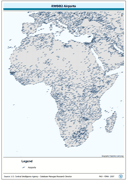
Point based representation of Airports. The RWDB_APRT shapefile data layer is comprised of 15044 derivative vector framework library features derived based on 1:3 000 000 data originally from RWDBII. The layer provides nominal analytical/mapping at 1:3 000 000. Data processing complete globally. Acronyms and Abbreviations: RWDB2 or RWDB II- Relational World Database II.
-

Topologically corrected polygonal derivative of 7 RWDB2 library layers to create continental baselines. The RWDB_BND-PY shapefile data layer is comprised of 20874 derivative vector framework library features derived based on 1:3 000 000 data originally from RWDBII. The layer provides nominal analytical/mapping at 1:3 000 000. Data processing complete globally. Acronyms and Abbreviations: RWDB2 or RWDB II- Relational World Database II.
-
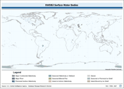
Enhanced SWB polygonal derivative based on 4 separate RWDB2 Library layers. The RWDB_SWB-PY shapefile data layer is comprised of 8750 derivative vector framework library features derived based on 1:3 000 000 data originally from RWDBII. The layer provides nominal analytical/mapping at 1:3 000 000. Data processing complete globally. Acronyms and Abbreviations: RWDB2 or RWDB II- Relational World Database II SWB - Surface Water Body
-

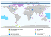
Ad2-Linear coastlines, national, 1st order subnational and other areas of sovereignty boundaries compiled from multiple RWDB2 source layers, circa 1997. The RWDB_AD2-LN shapefile data layer is comprised of 26648 derivative vector framework library features derived based on 1:3 000 000 data originally from RWDBII. The layer provides nominal analytical/mapping at 1:3 000 000. Data processing complete globally. Acronyms and Abbreviations: RWDB2 or RWDB II- Relational World Database II.
-
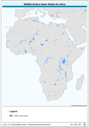
This dataset derives from the RWDB_SWB-PY shapefile data layer which covers the entire globe and is comprised of 8750 derivative vector framework library features derived based on 1:3,000,000 data originally from RWDBII. The original dataset is an enhanced SWB polygonal derivative based on 4 separate RWDB2 Library layers. The layer provides nominal analytical/mapping at 1:3,000,000. Acronyms and Abbreviations: RWDB2 or RWDB II- Relational World Database II SWB - Surface Water Body
-
Ad2-Polygonal representation of national, 1st-order subnational and other areas of sovereignty boundaries compiled from multiple RWDB2 source layers, circa 1997. The RWDB_AD2-PY shapefile data layer is comprised of 16035 derivative vector framework library features derived based on 1:3 000 000 data originally from RWDBII. The layer provides nominal analytical/mapping at 1:3 000 000. Data processing complete globally. Acronyms and Abbreviations: RWDB2 or RWDB II- Relational World Database II.