 FAO Map Catalog
urban areas
Type of resources
Available actions
Topics
Keywords
Contact for the resource
Provided by
Representation types
Update frequencies
status
Scale
-

Populated places including urbanized areas and villages within the Okavango Basin. Source: Digital Chart of the World (DCW). This dataset is part of the GIS Database for the Environment Protection and Sustainable Management of the Okavango River Basin project (EPSMO). Detailed information on the database can be found in the âGIS Database for the EPSMO Projectâ document produced by Luis Veríssimo (FAO consultant) in July 2009, and here available for download.
-
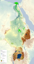
This map shows the Geographic Information System (GIS) ancillary information used to prepare thematic posters for the FAO-Nile Basin project. They are: -administrative units; -basin boundary; -boundary above water bodies; -country boundaries; canals&tunnels; -cities; -irrigated areas; -protected areas; -rivers; urban areas; -water bodies; -SRTM. Sources and information for each layer can be found in the "FAO Nile Information Products Synthesis Report" here available in the Distribution section of this metadata form.