 FAO Map Catalog
framework library
Type of resources
Available actions
Topics
Keywords
Contact for the resource
Provided by
Years
Representation types
Update frequencies
status
Scale
-
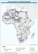
Robust centre-point derivative of SWB - Hydro polygonal features. The VMAP_PT shapefile data layer is comprised of 25128 derivative polygon framework library features derived based on 1:1 000 000 data originally from VMap0/DCW. The layer provides nominal analytical/mapping at 1:1 000 000. Seamlessly complete globally, with consolidation-harmonization @ ~70%, this Africa subset at final. Acronyms and Abbreviations: VMap0 - Vector Map for Level 0; SWB - Surface Water Body; DCW - Digital Chart of the World.
-
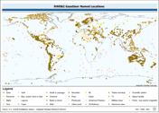
Point based gazetteer of named locations. The RWDB_GZTR shapefile data layer is comprised of 3031 derivative vector framework library features derived based on 1:3 000 000 data originally from RWDBII. The layer provides nominal analytical/mapping at 1:3 000 000. Data processing complete globally. Acronyms and Abbreviations: RWDB2 or RWDB II- Relational World Database II.
-
Seamless and topologically robust derivative of linear VMap0 - Ed5 Industry and related data layers. The INTDT_LN shapefile data layer is comprised of 82 derivative vector framework library features derived based on 1:1 000 000 data originally from VMap0, 5th Edition. The layer provides nominal analytical/mapping at 1:1 000 000. Data processing complete globally, this is an African subset. Acronyms and Abbreviations: VMap0 - Vector Map for Level 0.
-
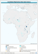
Seamless and topologically robust derivative of source VMap0 SWB and related hydrological features, i.e. swamps, etc. data layers. The VMAP_PY shapefile data layer is comprised of 25128 derivative vector framework library features derived based on 1:1 000 000 data originally from VMap0/DCW. The layer provides nominal analytical/mapping at 1:1 000 000. Seamlessly complete globally, with consolidation-harmonization @ ~70%, this Africa subset at final. Acronyms and Abbreviations: VMap0 - Vector Map for Level 0; SWB - Surface Water Body DCW - Digital Chart of the World.
-
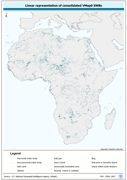
Robust separately encoded depiction of the SWB - Hydro polygonal outlines. The VMAP_LN shapefile data layer is comprised of 30413 derivative polygon framework library features derived based on 1:1 000 000 data originally from VMap0/DCW. The layer provides nominal analytical/mapping at 1:1 000 000. Seamlessly complete globally, with consolidation-harmonization @ ~70%, this Africa subset at final. Acronyms and Abbreviations: VMap0 - Vector Map for Level 0; SWB - Surface Water Body; DCW - Digital Chart of the World.
-
Seamless and topologically robust derivative of VMap0 - Ed5 data layers. The ED5LR_LN shapefile data layer is comprised of 5978 derivative vector framework library features derived based on 1:1 000 000 data originally from VMap0, 5th Edition. The layer provides nominal analytical/mapping at 1:1 000 000. Data processing complete globally, this is an African subset. Acronyms and Abbreviations: VMap0 - Vector Map for Level 0.
-
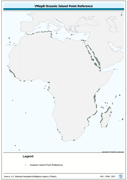
Oceanic point feature derivative of VMap0 - Ed5 Political Point data layer. The ISLND_PT shapefile data layer is comprised of 1474 derivative vector framework library features derived based on 1:1 000 000 data originally from VMap0, 5th Edition. The layer provides nominal analytical/mapping at 1:1 000 000. Data processing complete globally, this is an African subset. Acronyms and Abbreviations: VMap0 - Vector Map for Level 0.
-
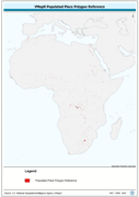
Seamless and topologically robust derivative of VMap0 - Ed5 data layers. The PPL_PY shapefile data layer is comprised of 1505 derivative vector framework library features derived based on 1:1 000 000 data originally from VMap0, 5th Edition. The layer provides nominal analytical/mapping at 1:1 000 000. Data processing complete globally, this is an African subset. Acronyms and Abbreviations: VMap0 - Vector Map for Level 0.
-
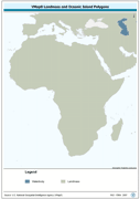
Seamless and topologically robust derivative of source VMap0 data layers for landmass and oceanic island data layers. The MASK_PY shapefile data layer is comprised of 2 derivative vector framework library features derived based on 1:1 000 000 data originally from VMap0, 5th Edition. The layer provides nominal analytical/mapping at 1:1 000 000. Data processing complete globally, this is an African subset. Acronyms and Abbreviations: VMap0 - Vector Map for Level 0.
-
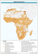
Seamless and topologically robust derivative of all linear Transport/Roads VMap0 - Ed5 data layers. The RD_LN shapefile data layer is comprised of 84205 derivative vector framework library features derived based on 1:1 000 000 data originally from VMap0, 5th Edition. The layer provides nominal analytical/mapping at 1:1 000 000. Data processing complete globally, this is an African subset. Acronyms and Abbreviations: VMap0 - Vector Map for Level 0.