 FAO Map Catalog
cities
Type of resources
Available actions
Topics
Keywords
Contact for the resource
Provided by
Years
Formats
Representation types
Update frequencies
status
Scale
-
Robust derivative of VMap0 - Ed5 data layers with harmonized encoding. The CAPTL_PT shapefile data layer is comprised of 55 derivative vector framework library features derived based on 1:1 000 000 data originally from VMap0, 5th Edition. The layer provides nominal analytical/mapping at 1:1 000 000. Data processing complete globally, this is an African subset. Acronyms and Abbreviations: VMap0 - Vector Map for Level 0.
-
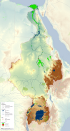
This map shows the Geographic Information System (GIS) ancillary information used to prepare thematic posters for the FAO-Nile Basin project. They are: -administrative units; -basin boundary; -boundary above water bodies; -country boundaries; canals&tunnels; -cities; -irrigated areas; -protected areas; -rivers; urban areas; -water bodies; -SRTM. Sources and information for each layer can be found in the "FAO Nile Information Products Synthesis Report" here available in the Distribution section of this metadata form.
-

On 8 November 2013, Typhoon Haiyan made landfall in the Philippines causing widespread devastation, tremendous loss of life and catastrophic impact on infrastructure and natural resources. As a result of the devastating damage to agriculture and fisheries sectors and the severe impact on lives and livelihoods FAO has declared Level 3 Emergency Response. In response to the call for needs assessment and coordinating humanitarian assistance in agriculture and fisheries sectors the FAO, Land and Water Division Geospatial Unit collected a number of datasets from various sources including FAO, WFP, UNITAR-UNOSAT, EC-JRC, USDA, USGS as well as updated reports from national agencies as well as the National Disaster Risk Reduction and Management council. A set of data were also used as ancillary data to support the impact assessment analysis. They are organized as follows: BASE LAYERS - Coastline (OCHA); National and sub-national boundaries (FAO GAUL2012); Contour lines (OCHA); Rivers and Lakes (The Philippines' National Mapping and Resource Information Authority- NMRIA); Hydrobasins (FAO) - Cities (NGA/VPAM-0); Points of interest (NMRIA). INFRASTRUCTURES - Roads, Railroads and Airports (NMRIA). LAND COVER AND LAND USE - Land cover (ESA Globcover); Mangroves (FAO GLC-Share); Forest (FAO FRA2010); Land use systems (FAO). FARMING - Cattle density (FAO); Pig density (FAO); Poultry density (FAO).