 FAO Map Catalog
boundary
Type of resources
Available actions
Topics
Keywords
Contact for the resource
Provided by
Formats
Representation types
Update frequencies
status
-
Extent of the Nura-Sarysu Water Economic basin. The territory of the Nura-Sarysu basin includes the basins of the rivers Nura and Sarysu, and the lakes Tengiz and Karasor.
-
Extent of the water catchment area of Lake Tengiz which in Kazakhstan.
-
Extent of the Nura-Sarysu Water Economic basin with complete drainage area of the rivers Nura and Sarysu and Lake Tengiz with buffer.
-
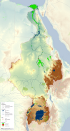
This map shows the Geographic Information System (GIS) ancillary information used to prepare thematic posters for the FAO-Nile Basin project. They are: -administrative units; -basin boundary; -boundary above water bodies; -country boundaries; canals&tunnels; -cities; -irrigated areas; -protected areas; -rivers; urban areas; -water bodies; -SRTM. Sources and information for each layer can be found in the "FAO Nile Information Products Synthesis Report" here available in the Distribution section of this metadata form.