 FAO Map Catalog
basins
Type of resources
Available actions
Topics
Keywords
Contact for the resource
Provided by
Years
Formats
Representation types
Update frequencies
status
Scale
-
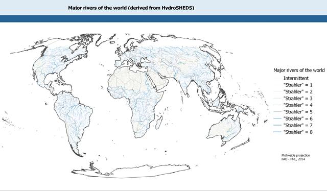
This dataset is derived from the World Wildlife Fund's (WWF) HydroSHEDS drainage direction layer and a stream network layer. The source of the drainage direction layer was the 15-second Digital Elevation Model (DEM) from NASA's Shuttle Radar Topographic Mission (SRTM). The raster stream network was determined by using the HydroSHEDS flow accumulation grid, with a threshold of about 1000 km² upstream area. The stream network dataset consists of the following information: the origin node of each arc in the network (FROM_NODE), the destination of each arc in the network (TO_NODE), the Strahler stream order of each arc in the network (STRAHLER), numerical code and name of the major basin that the arc falls within (MAJ_BAS and MAJ_NAME); - area of the major basin in square km that the arc falls within (MAJ_AREA); - numerical code and name of the sub-basin that the arc falls within (SUB_BAS and SUB_NAME); - area of the sub-basin in square km that the arc falls within (SUB_AREA); - numerical code of the sub-basin towards which the sub-basin flows that the arc falls within (TO_SUBBAS) (the codes -888 and -999 have been assigned respectively to internal sub-basins and to sub-basins draining into the sea). The attributes table now includes a field named "Regime" with tentative classification of perennial ("P") and intermittent ("I") streams.
-

This dataset of sub-basins comes from the USGS HydroSHEDS layers and identifies the following eighteen sub-basins: Akoba, Bahr al arab, Buhayrat abyad, Gelha, Khawr biban, Khawr tunbak, Khawr_marchar, Kidepo, Kwahr as sidrah, Kwahr m’ boloko, Lake turkana, Lotagipi swamp, Sopo, Sue, White nile 3, White nile 4, White nile 5 and White nile 6. The HydroSHEDS are hydrological data and maps based on SHuttle Elevation Derivatives at multiple Scales of the US Geological Survey. The USGS HydroSHEDS layer is based on high-resolution elevation data obtained during a Space Shuttle flight of NASA’s Shuttle Radar Topography Mission (SRTM). Around twenty-three sub-basins fall in the South Sudan area, including five sub-basins of which only a small portion is comprised. They are part of two main hydrological basins: the biggest part of the study area belongs to the Nile basin, while the eastern part of the area belongs to the Rift Valley basin. The delineation of the hydrological basins can be considered as the starting point in the analysis of the hydrological cycle to study surface water resources systems.