 FAO Map Catalog
Zimbabwe
Type of resources
Available actions
Topics
Keywords
Contact for the resource
Provided by
Formats
Representation types
Update frequencies
status
Scale
-

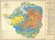
Provisional soil map of Southern Rhodesia
-

Provisional Soil Map of Southern Rhodesia and the Tati Concession (3 000 000)
-
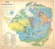
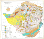
Exploratory soil map of Rhodesia
-
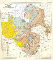
Provisional soil map of Zimbabwe Rhodesia (ed. 2)
-
Vegetation map of the Federation of Rhodesia and Nyasaland
-
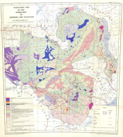
Provisional geological map of the Federation of Rhodesia and Nyasaland
-
(7th edition, reprinted 1991)
-
A set of 6 medium scale (250k) topographic maps, that share geographical overlapping with the Okavango Basin. Source: The Surveyor General, Harare, Zimbabwe. Original data georeferenced under the GIS EPSMO program. This dataset is part of the GIS Database for the Environment Protection and Sustainable Management of the Okavango River Basin project (EPSMO). Detailed information on the database can be found in the “GIS Database for the EPSMO Project†document produced by Luis Veríssimo (FAO consultant) in July 2009, and here available for download.
-

This layer represents the political administration level 1 boundaries (level of municipality, (Region) and subdistrict) in the 4 riparian countries, that share geographical overlapping with the Okavango Basin: Angola, Namibia, Botswana and Zimbabwe. Source: Generated under the GIS EPSMO program. This dataset is part of the GIS Database for the Environment Protection and Sustainable Management of the Okavango River Basin project (EPSMO). Detailed information on the GIS Database can be found in the “GIS Database for the EPSMO Project†document produced by Luis Veríssimo (FAO consultant) in July 2009, and here available for download.
-
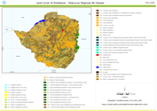
This land cover data set is derived from the original raster based Globcover regional (Africa) archive. It has been post-processed to generate a vector version at national extent with the LCCS regional legend (46 classes). This database can be analyzed in the GLCN software Advanced Database Gateway (ADG), which provides a user-friendly interface and advanced functionalities to breakdown the LCCS classes in their classifiers for further aggregations and analysis. The data set is intended for free public access. The shape file's attributes contain the following fields: -Area (sqm) -ID -Gridcode (Globcover cell value) -LCCCode (unique LCCS code) You can download a zip archive containing: -the shape file (.shp) -the ArcGis layer file with global legend (.lyr) -the ArcView 3 legend file (.avl) -the LCCS legend tables (.xls)