 FAO Map Catalog
Eritrea
Type of resources
Available actions
Topics
Keywords
Contact for the resource
Provided by
Years
Formats
Representation types
Update frequencies
status
Scale
-
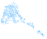
The rivers have been produced from visual interpretation of digitally enhanced LANDSAT TM images (Bands 4,3,2) acquired mainly in the year 1999.
-

The Soil and Terrain Database Map of East Africa is a computer system for the storage, display, interpretation and analysis of the Soil Map of East Africa at scale 1:1.000.000. The system consists of the soil and terrain database with corresponding soil maps, that are accessed by the programme for visualization in different viewer formats. Various interactive querying and selection tools provide easy access to specific parts of the database for display as thematic map, data browser or data entry form.
-
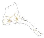
The full resolution dataset of roads have been produced from visual interpretation of digitally enhanced LANDSAT TM images (Bands 4,3,2) acquired mainly in the year 1999.
-
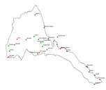
The full resolution dataset of towns was developed from data from the National Imagery and Mapping Agency (NIMA).
-

The Soil and Terrain Database Map of East Africa is a computer system for the storage, display, interpretation and analysis of the Soil Map of East Africa at scale 1:1.000.000. The system consists of the soil and terrain database with corresponding soil maps, that are accessed by the programme for visualization in different viewer formats. Various interactive querying and selection tools provide easy access to specific parts of the database for display as thematic map, data browser or data entry form.
-

This is a thematic aggregation of the original full resolution Geomorphology/Landform and Lithology database which has been produced from visual interpretation of digitally enhanced LANDSAT TM images acquired mainly in the year 1999. The landform classes have been developed using the ITC (International Institute for Geo-Information Science and Earth Observation) and SOTER (Soil and Terrain Database) methods. This thematic aggregation groups the lithology codes into three main groupings based on geological origin (i.e. Igneous, sedimentary or metamorphic). The structure of the derived legend follows a specific criteria that allows and easy correlation between these classes and the standardised one listed in LCCS (SOTER classification first and second level). SOTER is a pure Parametric or Morphometric classification. The main origin or process of terrain units is an important descriptive element because it relates to the dominant exogenous or endogenous processes. This aspect in a general classification gives a meaningful grouping and has analytical value. The proposed legend is structured in such a way that it can be read, not only from the Morphometric point of view as in SOTER, but also taking into account the main origin and the age of landforms (mainly derived from the lithology legend). Lithology is linked with the mapping units, but is listed separately. See the full landform/lithology legend in the resource section.
-
The full resolution dataset of landform and lithology has been produced from visual interpretation of digitally enhanced LANDSAT TM images acquired mainly in the year 1999. The landform classes have been developed using the ITC (International Institute for Geo-Information Science and Earth Observation) and SOTER (Soil and Terrain Database) methods. The structure of the derived legend follows a specific criteria that allows an easy correlation between these classes and the standardised one listed in LCCS (SOTER classification first and second level). SOTER is a pure Parametric or Morphometric classification. The main origin or process of terrain units is an important descriptive element because it realtes to the dominant exogenous or endogenous processes. this aspect in a general classification gives a meaningful grouping and has analytical value. The proposed legend is structured in such a way that it can be read, not only from the Morphometric point of view as in SOTER, but also taking into account the main origin and the age of landforms (mainly derived from the lithology legend). Lithology is linked with the mapping units, but is listed seperately. See the full landform/lithology legend in the resource section.
-
This is a thematic aggregation of the original full resolution Geomorphology/Landform and Lithology database which has been produced from visual interpretation of digitally enhanced LANDSAT TM images acquired mainly in the year 1999. The landform classes have been developed using the ITC (International Institute for Geo-Information Science and Earth Observation) and SOTER (Soil and Terrain Database) methods. This thematic aggregation groups the landform codes into broader landform units. The structure of the derived legend follows a specific criteria that allows and easy correlation between these classes and the standardised one listed in LCCS (SOTER classification first and second level). SOTER is a pure Parametric or Morphometric classification. The main origin or process of terrain units is an important descriptive element because it relates to the dominant exogenous or endogenous processes. This aspect in a general classification gives a meaningful grouping and has analytical value. The proposed legend is structured in such a way that it can be read, not only from the Morphometric point of view as in SOTER, but also taking into account the main origin and the age of landforms (mainly derived from the lithology legend). Lithology is linked with the mapping units, but is listed separately. See the full landform/lithology legend in the resource section.
-
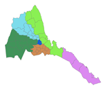
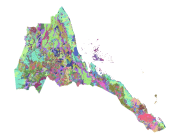
The national and administrative boundaries have been provided by the NFPI. Coastlines have been adapted to match the landcover dataset.
-
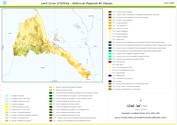
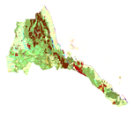
This land cover data set is derived from the original raster based Globcover regional (Africa) archive. It has been post-processed to generate a vector version at national extent with the LCCS regional legend (46 classes). This database can be analyzed in the GLCN software Advanced Database Gateway (ADG), which provides a user-friendly interface and advanced functionalities to breakdown the LCCS classes in their classifiers for further aggregations and analysis. The data set is intended for free public access. The shape file's attributes contain the following fields: -Area (sqm) -ID -Gridcode (Globcover cell value) -LCCCode (unique LCCS code) You can download a zip archive containing: -the shape file (.shp) -the ArcGis layer file with global legend (.lyr) -the ArcView 3 legend file (.avl) -the LCCS legend tables (.xls)