 FAO Map Catalog
Keyword
Biogeography
Type of resources
Available actions
Topics
Keywords
Contact for the resource
Provided by
Years
Formats
Representation types
Update frequencies
status
Scale
From
1
-
2
/
2
-
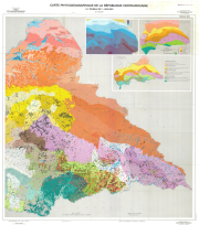
Include: Divisions administratives (2 500 000) - Pluviométrie, climats (2 500 000), Sheet East and West, Description of the mapping units
-
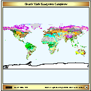
Vector map based on a Digital Raster Data 10-minute Cartesian Orthonormal Geodetic 1080x2160 grid. Source: Global Ecosystems Map by J. S. Olson 1992 (Global Patterns Company) Olson, J.S. 1992. World Ecosystems (WE1.4). Digital Raster Data on a 10-minute Cartesian Orthonormal Geodetic 1080x2160 grid. More information on the source at https://www.ngdc.noaa.gov/ecosys/cdroms/AVHRR97_d2/document/ncillary/owe/aareadme.htm