 FAO Map Catalog
3500000
Type of resources
Available actions
Topics
Keywords
Contact for the resource
Provided by
Years
Representation types
Update frequencies
status
Scale
-
Consolidated Table of 2001 Decadal Rainfall. The RFE_2001 tabular data layer is comprised of 471688 derivative raster precipitation features derived based on 8 kilometers data originally from EDC. The layer provides nominal analytical/mapping at 1:3 500 000. Acronyms and Abbreviations: EDC - USGS EROS (Earth Resources Observation Systems) Data Center.
-
Consolidated Table of 1999 Decadal Rainfall. The RFE_1999 tabular data layer is comprised of 471688 derivative raster precipitation features derived based on 8 kilometers data originally from EDC. The layer provides nominal analytical/mapping at 1:3 500 000. Acronyms and Abbreviations: EDC - USGS EROS (Earth Resources Observation Systems) Data Center.
-
Consolidated Table of 2002 Decadal Rainfall. The RFE_2002 tabular data layer is comprised of 471688 derivative raster precipitation features derived based on 8 kilometers data originally from EDC. The layer provides nominal analytical/mapping at 1:3 500 000. Acronyms and Abbreviations: EDC - USGS EROS (Earth Resources Observation Systems) Data Center.
-
Consolidated Table of 7 Year Short Average Decadal Rainfall. The RFE_SAVG tabular data layer is comprised of 471688 derivative raster precipitation features derived based on 8 kilometers data originally from EDC. The layer provides nominal analytical/mapping at 1:3 500 000. Acronyms and Abbreviations: EDC - USGS EROS (Earth Resources Observation Systems) Data Center.
-
Consolidated Table of 1998 Decadal Rainfall. The RFE_1998 tabular data layer is comprised of 471688 derivative raster precipitation features derived based on 8 kilometers data originally from EDC. The layer provides nominal analytical/mapping at 1:3 500 000. Acronyms and Abbreviations: EDC - USGS EROS (Earth Resources Observation Systems) Data Center.
-
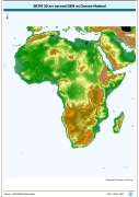
Enhanced SRTM-GTopo30 DEM with ocean values masked and set to null. SRTM is Shuttle Radar Topography Mission; GT30/GTopo30 is Global Topographic 30 arc second DEM database, nominal 1km postings; DEM is Digital Elevation Model. The SRTMGT30 grid data layer is comprised of 10800x11400 derivative raster digital elevation model features derived based on 0.00833_ data originally from SRTM 30as v.2.
-
Consolidated Table of 2003 Decadal Rainfall. The RFE_2003 tabular data layer is comprised of 471688 derivative raster precipitation features derived based on 8 kilometers data originally from EDC. The layer provides nominal analytical/mapping at 1:3 500 000. Acronyms and Abbreviations: EDC - USGS EROS (Earth Resources Observation Systems) Data Center.
-
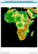
Consolidated SRTM-GTopo30 DEM with masked ocean values backfilled based on ETopo2 Bathymetry. SRTM is Shuttle Radar Topography Mission; GT30/GTopo30 is Global Topographic 30 arc second DEM database, nominal 1km postings; DEM is Digital Elevation Model. The SRTMBATH grid data layer is comprised of 10800x11400 derivative raster digital elevation model features derived based on 0.00833_ data originally from SRTM 30as v.2.
-
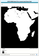
A 30 arc-second land/ocean mask derived from the SRTM -SWBD nominal 30 metre coastline data. SRTM is Shuttle Radar Topography Mission; SWBD is Surface Waterbody . The SRC_MASK grid data layer is comprised of 10800x11400 derivative raster digital elevation model features derived based on 0.00833_ data originally from SRTM 30as v.2.
-
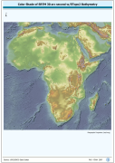
2.5d enhanced RGB of SRTM-30 terrestrial elevation and ETopo2 bathymetric data. RGB is 3 band spatial imagery forced into the Red:Green:Blue spectrum; SRTM is Shuttle Radar Topography Mission; ETopo2 is a 2 minute Elevation Topographic DEM including bathymetry. The SRTM30_SHDBATH image data layer is comprised of 9600x9600 derivative raster digital elevation model features derived based on 0.00833_ data originally from SRTM 30as v.2.