 FAO Map Catalog
9-05
Type of resources
Available actions
Topics
Keywords
Contact for the resource
Provided by
Years
Representation types
Update frequencies
status
Scale
-

Main aquatic species data layer containing point and ancillary tabular attributes of capture data. Verified 35 292 location references comprising 247 unique aquatic specie; unverified: 1 080 location references covering 517 unique aquatic specie. The AQ_SPECIES shapefile data layer is comprised of 766 derivative point aquatic species features derived based on 1:1 000 000 data originally from SAIAB. The layer provides nominal analytical/mapping at 1:1 000 000. Acronyms and Abbreviations: SAIAB - South African Institute for Aquatic Biodiversity (formerly known as JLB Institute of Ichthyology).
-
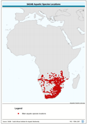
Similar to main aquatic species data layer of capture records of 35 292 verified location references for 247 specie and 1 080 unverified location references for 517 other aquatic specie; includes restricted data for 32 endangered/threatened specie. The AQ_SPECIES shapefile data layer is comprised of 798 derivative point aquatic species features derived based on 1:1 000 000 data originally from FIRI. The layer provides nominal analytical/mapping at 1:1 000 000. Acronyms and Abbreviations: FIRI - Inland Water resources and Aquaculture Service, recently changed in FIMA - Aquaculture Management and Conservation Service