 FAO Map Catalog
2014
Type of resources
Available actions
Topics
Keywords
Contact for the resource
Provided by
Years
Formats
Representation types
Update frequencies
status
Scale
Resolution
-
**Table content** - Year - Indicator - Value - Flag - Unit
-
**Table content** - Year - Indicator code - Crop (code) - Value - Flag - Unit measure code
-
**Table content** - Year - Indicator - Product - Value - Flag - Unit
-
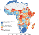
The “technological capital index” symbolizes the physical means that determine the potential adaptive capacity degree of a particular unit of analysis in 2010. It is linked with the diffusion of basic life technology and infrastructure (e.g. transportation network). It is the combination of two underlying indexes: the “household technology index” and the “infrastructure index”. These original indexes correspond to the two principal components recognized by Principal Component Analysis among 10 potential variables. The analysis assigned relative weights to the “household technology index” and the “infrastructure index”, that are 0.62 and 0.38, respectively. This dataset has been produced in the framework of the “Climate change predictions in Sub-Saharan Africa: impacts and adaptations (ClimAfrica)” project, Work Package 4 (WP4). More information on ClimAfrica project is provided in the Supplemental Information section of this metadata.
-
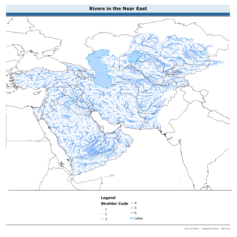
The rivers of the Near East dataset is derived from the World Wildlife Fund's (WWF) HydroSHEDS drainage direction layer and a stream network layer. The source of the drainage direction layer was the 15-second Digital Elevation Model (DEM) from NASA's Shuttle Radar Topographic Mission (SRTM). The raster stream network was determined by using the HydroSHEDS flow accumulation grid, with a threshold of about 1000 km² upstream area. The stream network dataset consists of the following information: the origin node of each arc in the network (FROM_NODE), the destination of each arc in the network (TO_NODE), the Strahler stream order of each arc in the network (STRAHLER), numerical code and name of the major basin that the arc falls within (MAJ_BAS and MAJ_NAME); - area of the major basin in square km that the arc falls within (MAJ_AREA); - numerical code and name of the sub-basin that the arc falls within (SUB_BAS and SUB_NAME); - area of the sub-basin in square km that the arc falls within (SUB_AREA); - numerical code of the sub-basin towards which the sub-basin flows that the arc falls within (TO_SUBBAS) (the codes -888 and -999 have been assigned respectively to internal sub-basins and to sub-basins draining into the sea). The attributes table now includes a field named "Regime" with tentative classification of perennial ("P") and intermittent ("I") streams.
-
**Table content** - Year - Indicator code - Administrative Level 2 (code) - Crop (code) - Value - Flag - Unit of measure code
-
**Table content** - Year - Indicator - Product - Value - Flag - Unit
-
**Table content** - Year - Indicator code - Sector (code) - Value - Flag - Unit of measure code
-
**Table content** - Year - Indicator - Product - Value - Flag - Unit
-
**Table content** - Year - Indicator - Species - Value - Flag - Unit