 FAO Map Catalog
Agro-MAPS A global spatial database of agricultural land-use statistics aggregated by sub-national administrative districts
Agro-MAPS consists of selected agricultural land-use statistics (crop production, area harvested and crop yield) aggregated by sub-national administrative districts for selected years. The full Agro-MAPS database currently contains data for 134 countries - 130 countries at admin1 level; 59 countries at admin2 level. These countries represent 92% of the world land surface. Users can interactively query and display Agro-MAPS data as maps, for a given country or region (Africa, Asia, North America, Latin America & the Caribbean, Asia, Near East in Asia, Oceania).
Simple
- Date ( Publication )
- 2005-01-01
- Edition
- 01
- Presentation form
- Digital table
- Purpose
- Agro-MAPS was created to support a wide range of analyses related to agriculture ? e.g. land degradation assessment and remediation, food security and early warning, climate change, policy formulation and planning in rural development
- Status
- On going
Owner
Food and Agriculture Organization (FAO)
-
Hubert George
(
Technical officer
)
+39-570 56275
Viale delle Terme di Caracalla
,
Rome
,
Lazio
,
00100
,
Italy
+39-57056234
+39-570 56275
- Maintenance and update frequency
- Irregular
- Keywords ( Theme )
-
- land use
- agricultural statistics
- crop production
- cropland
- area harvested
- crop yield
- administrative districts
- Tag_LUS
- Tag_land
- Keywords ( Place )
-
- World
- Other constraints
- Users should acknowledge the use of Agro-MAPS data. Consult Agro-MAPS User Agreement (for details see web site or CD-ROM publication)
- Metadata language
- eng
- Character set
- UTF8
- Topic category
-
- Geoscientific information
- Begin date
- 2005-01-01
N
S
E
W
))
- Supplemental Information
- Available shapefiles are provided for rapid visual browsing only; use shapefiles of known reliability for subsequent spatial analyses
- OnLine resource
-
Agro-MAPS
(
WWW:LINK-1.0-http--link
)
global spatial database of agricultural land-use statistics aggregated by sub-national administrative districts
gmd:MD_Metadata
- File identifier
- db78c740-88fd-11da-a88f-000d939bc5d8 XML
- Metadata language
- eng
- Character set
- UTF8
- Date stamp
- 2004-12-16T17:16:52
- Metadata standard name
- ISO 19115:2003/19139
- Metadata standard version
- 1.0
Point of contact
Food and Agriculture Organization (FAO)
-
Hubert George
(
Technical Officer
)
+39-570 56275
Viale delle Terme di Caracalla
,
Rome
,
Lazio
,
00100
,
Italy
+39-57056234
+39-570 56275
Overviews
thumbnail
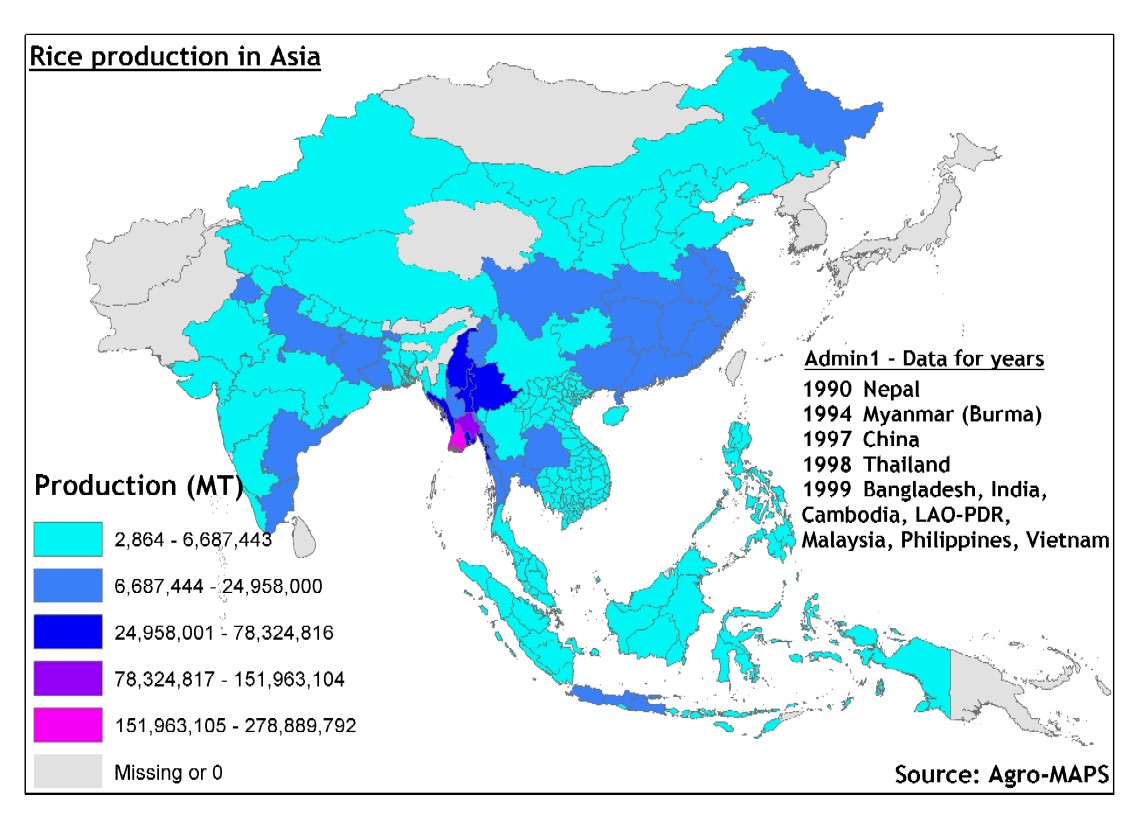
large_thumbnail
Spatial extent
N
S
E
W
Provided by

Associated resources
Not available