 FAO Map Catalog
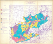
Haute vallée de la Medjerdah, Périmètre de Souk el Khemis. Carte des aptitudes des sols aux cultures irriguées (Tunisia)
Include:
Carte des aptitudes des sols aux cultures irriguées
Simple
- Date ( Publication )
- 1964-01-01
- Presentation form
- Hardcopy map
- Status
- Historical archive
Point of contact
FAO - UN AGL Documentation Center
Via delle Terme di Caracalla
,
Rome
,
00100
,
Italy
- Hours of service
- 8.30 - 17.00
- Keywords
-
- Land
- Suitability
- Keywords
-
- Land Suitability
- Dry Farming
- Irrigated Farming
- Keywords ( Place )
-
- Tunisia
- Denominator
- 100000
- Metadata language
- fre
- Character set
- UTF8
- Topic category
-
- Farming
N
S
E
W
))
- Supplemental Information
- ISIS Identifier: 003025; Number of sheets: 2; Type of material: hand-coloured
Distributor
- Ordering instructions
- Location of the data: FAO - AGL TUNISIA/LAND USE
- Name
- No digital format
- Version
- n.a.
- OnLine resource
- tunisia-3025-carte_des_aptitudes_des_sols_aux_cultures_irriguees-land_use_1-50,000.jpg ( WWW:DOWNLOAD-1.0-http--download )
- Hierarchy level
- Dataset
gmd:MD_Metadata
- File identifier
- c158343d-0a38-4dd8-9c2f-1d570079b96e XML
- Metadata language
- eng
- Character set
- UTF8
- Date stamp
- 2019-11-22T14:19:26
- Metadata standard name
- ISO 19115:2003/19139
- Metadata standard version
- 1.0
Overviews
thumbnail

large_thumbnail
Spatial extent
N
S
E
W
Provided by

Associated resources
Not available