 FAO Map Catalog
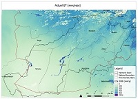
Water Accounting through Remote Sensing of Helmand River Basin
Remote Sensing based Water Accounting (WA+) of the Helmand River Basin (Afghanistan, Iran, Pakistan). Spatially explicit results include: land and water use classification, actual evapotranspiration, biomass, yields, irrigated crop water productivity.
More information on WA+ is available through www.wateraccounting.org
Simple
- Date ( Publication )
- 2011-07-19T14:01:00
- Presentation form
- Digital map
- Purpose
- This study is part of a broader TCP project on water resources availability and use in Afghanistan river basins (TCP/AFG/3402).
- Status
- On going
- Maintenance and update frequency
- As needed
- Keywords ( Theme )
-
- water resources
- hydrology
- irrigation
- Tag_AQUASTAT
- Keywords ( Place )
-
- Afghanistan
- Access constraints
- Copyright
- Spatial representation type
- Vector
- Denominator
- 100000
- Metadata language
- eng
- Character set
- UTF8
- Topic category
-
- Boundaries
))
Vertical extent
- Reference system identifier
- WGS 84 - UTM zone 42N
- OnLine resource
-
WA+ website
(
WWW:LINK-1.0-http--related
)
WA+ website
- OnLine resource
-
wululc.rar
(
WWW:DOWNLOAD-1.0-http--download
)
Water use / land use / land cover (Geotiff file, 0.5 MB. Codes and descriptions are available in the report)
- OnLine resource
-
Helmand_WAreport.pdf
(
WWW:DOWNLOAD-1.0-http--download
)
WA+ report (pdf)
- OnLine resource
-
ETa_y07-11.rar
(
WWW:DOWNLOAD-1.0-http--download
)
Annual actual evapotranspiration, downscaled, 2007-2011 (tif, 56 MB)
- Hierarchy level
- Dataset
gmd:MD_Metadata
- File identifier
- b4b8772d-6c3a-4c8c-a86f-595a85c71bd2 XML
- Metadata language
- eng
- Character set
- UTF8
- Date stamp
- 2016-01-19T09:04:48
- Metadata standard name
- ISO 19115:2003/19139
- Metadata standard version
- 1.0
Overviews

Spatial extent
Provided by
