 FAO Map Catalog
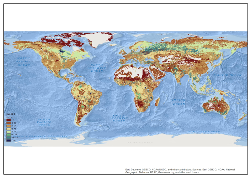
Global Sub Soil Organic Carbon (30 - 100 cm) Stock - 30 arcsec
Global Map (resolution 30 arcsec) of SubSoil Organic Carbon Stock (30 - 100 cm depth). This dataset has been created by spatializing the information of over 17.000 soil samples from many databases (WISE3, USDA-NRCS- SOTER. ISRIC, University of Tuscia, SPADE, Russia, FAO et al.). Land Cover information comes from FAO GLC-SHARE Land Cover Database and the Harmonized Soil World Database (ver 1.21 -
http://webarchive.iiasa.ac.at/Research/LUC/External-World-soil-database/HTML/
). Soil Organic Carbon (SOC) stock in the map is represented as a continuous value and expressed in Mg/ha.
Simple
- Date ( Publication )
- 2014-04-14T18:07:00
- Edition
- 1.0 Beta
- Presentation form
- Digital map
- Purpose
- This map has been produced to evaluate the stock of Organic Carbon Stock in sub (30 - 100 cm depth) soil.
- Status
- Completed
Author
CMCC - IAFENT
-
Sergio Noce
(
GIS Analyst, Consultants
)
+3907611710731
Via Pacinotti n.5
,
Viterbo
,
01100
,
Italy
+3907611710299
+3907611710731
Author
CMCC - IAFENT
-
Monia Santini
(
GIS Analyst, Consultants
)
+3907611710731
Via Pacinotti n.5
,
Viterbo
,
01100
,
Italy
+3907611710299
+3907611710731
Author
University of Tuscia, DIBAF Department
-
Tommaso Chiti
(
Consultant
)
+390761357389
Via S.Camillo de Lellis snc
,
Viterbo
,
01100
,
Italy
+390761357251
+390761357389
- Maintenance and update frequency
- Not planned
- Keywords ( Theme )
-
- soil
- sub soil
- stock
- Soil Organic Carbon
- SOC
- GeoCarbon
- Tag_SOC
- Keywords ( Place )
-
- World
- GEMET - INSPIRE themes, version 1.0 ( Theme )
-
- Soil
- Access constraints
- Copyright
- Use constraints
- Copyright
- Spatial representation type
- Grid
- Denominator
- 100000
- Metadata language
- en
- Character set
- UTF8
- Topic category
-
- Environment
- Begin date
- 2014-04-14T18:14:00
N
S
E
W
))
- Reference system identifier
- WGS 1984
- Number of dimensions
- 2
- Dimension name
- Row
- Dimension size
- 21600
- Resolution
- 30 arcsec
- Dimension name
- Column
- Dimension size
- 43200
- Dimension name
- Vertical
- Cell geometry
- Area
- Transformation parameter availability
- No
- OnLine resource
-
GeoCarbon Website
(
WWW:LINK-1.0-http--link
)
GeoCarbon Website
- OnLine resource
- https://data.apps.fao.org/map/catalog/srv/eng/resources.get?id=47984&fname=&access=private ( WWW:DOWNLOAD-1.0-http--download )
- Protocol
- OGC:WMS-1.1.1-http-get-map
- Hierarchy level
- Dataset
- Statement
- Update of coarser resoluted "Actual Carbon Sequestration for SubSoil"
gmd:MD_Metadata
- File identifier
- 83e9c2a3-5e09-4345-9222-6bb7889c879a XML
- Metadata language
- en
- Character set
- UTF8
- Date stamp
- 2014-11-13T17:25:46
- Metadata standard name
- ISO 19115:2003/19139
- Metadata standard version
- 1.0
Distributor
FAO - NRL
-
Renato Cumani
(
Land and Water Officer
)
Viale delle Terme di Caracalla
,
Rome
,
00153
,
Italy
Overviews

thumbnail
large_thumbnail
Spatial extent
N
S
E
W
Provided by

Associated resources
Not available