 FAO Map Catalog
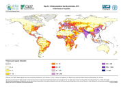
Global population density estimates, 2015 (FGGD)
Simple
- Date ( Publication )
- 2007-05-10
- Edition
- 1.0
- Presentation form
- Digital map
- Purpose
- The FGGD Digital Atlas consists of more than 100 global database that allows to analyse food insecurity and poverty in relation to the environment.
- Status
- Completed
- Maintenance and update frequency
- As needed
- Keywords ( Theme )
-
- population density
- demographic data
- Keywords ( Place )
-
- World
- Access constraints
- Copyright
- Use constraints
- Copyright
- Spatial representation type
- Grid
- Metadata language
- eng
- Character set
- UTF8
- Topic category
-
- Society
))
- Supplemental Information
- This dataset is contained in Module 2 "Population" of Food Insecurity, Poverty and Environment Global GIS Database (FGGD) (FAO, 2007).
- Reference system identifier
- GCS_WGS_1984
- Number of dimensions
- 2
- Dimension name
- Row
- Dimension size
- 3432
- Resolution
- 0.041667 ,
- Dimension name
- Column
- Dimension size
- 8640
- Resolution
- 0.041667 ,
Axis Dimensions Properties
- Cell geometry
- Area
- Transformation parameter availability
- Yes
- Distribution format
-
-
TIFF
(
)
-
TIFF
(
)
- OnLine resource
-
Map_2_3.zip
(
WWW:DOWNLOAD-1.0-http--download
)
Global population density estimates, 2015 (ESRI GRID Format - 115 Mb)
- OnLine resource
-
FAO, 2005. "Mapping global urban and rural population distributions"
(
WWW:LINK-1.0-http--link
)
FAO, 2005. "Mapping global urban and rural population distributions"
- OnLine resource
-
geonetwork:pop_dens2015_14053
(
OGC:WMS-1.1.1-http-get-map
)
Global population density estimates
Data quality info
gmd:MD_Metadata
- File identifier
- 6d78b970-5883-11db-b1aa-000d939bc5d8 XML
- Metadata language
- eng
- Character set
- UTF8
- Date stamp
- 2023-01-19T15:22:59
- Metadata standard name
- ISO 19115:2003/19139
- Metadata standard version
- 1.0
Overviews

Spatial extent
Provided by
