 FAO Map Catalog
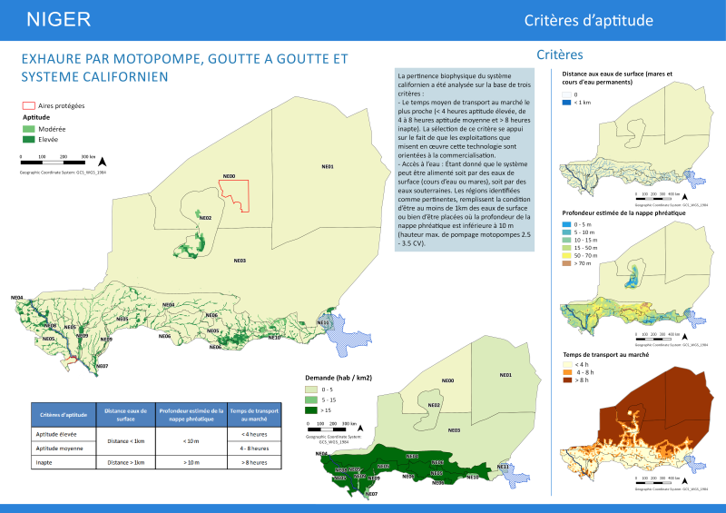
NIGER - Agriculture Water Management Investments: Drip Irrigation and Low pressure irrigation system Biophysical Suitability
Physical suitability for Drip irrigation and low pressure irrigation systems (Californian) has been assessed on the basis of:
Travel time to markets: Setting a threshold < 4 hours High suitability, 4-8 hours Medium and >8hours low we refine a bit more the suitability. Input grid: Travel time to the closest city with more than 20.000 inhabitants.
(http://www.fao.org/geonetwork/srv/en/main.home?uuid=e08b8b0c-8c5f-44b9-bbcf-45a14db88975)
Groundwater potential: An estimated Static Groundwater Level Depth has been generated by interpolating a boreholes georeferenced database provided by the Ministère de lâHydraulique du Niger. A 10 m depth threshold was stablished taking into account that the most common 3.5 CV small motor pumps have 10m as maximum pumping height.
Proximity to surface water (1km buffer distance)
Simple
- Date ( Publication )
- 2016-11-22T00:00:00
- Presentation form
- Digital map
- Purpose
- The map has been prepared for the project More effective and Sustainable Investments in Water for poverty reduction, funded by IFAD
- Status
- On going
- Maintenance and update frequency
- As needed
- Keywords ( Theme )
-
- BMGF-AWS
- water management
- Tag_AQUASTAT
- Tag_Water-Management
- Keywords ( Place )
-
- Niger
- Access constraints
- Copyright
- Use constraints
- Copyright
- Spatial representation type
- Vector
- Denominator
- 1000000
- Metadata language
- eng
- Character set
- UTF8
- Topic category
-
- Boundaries
))
- Reference system identifier
- WGS 1984
- Geometric object type
- Complex
- OnLine resource
- NI_GG_Clf.rar ( WWW:DOWNLOAD-1.0-http--download )
- Hierarchy level
- Dataset
gmd:MD_Metadata
- File identifier
- 61cab814-cc7d-44a2-b363-d2a540b6f9a3 XML
- Metadata language
- eng
- Character set
- UTF8
- Date stamp
- 2019-11-22T10:44:13
- Metadata standard name
- ISO 19115:2003/19139
- Metadata standard version
- 1.0
Overviews

Spatial extent
Provided by
