 FAO Map Catalog
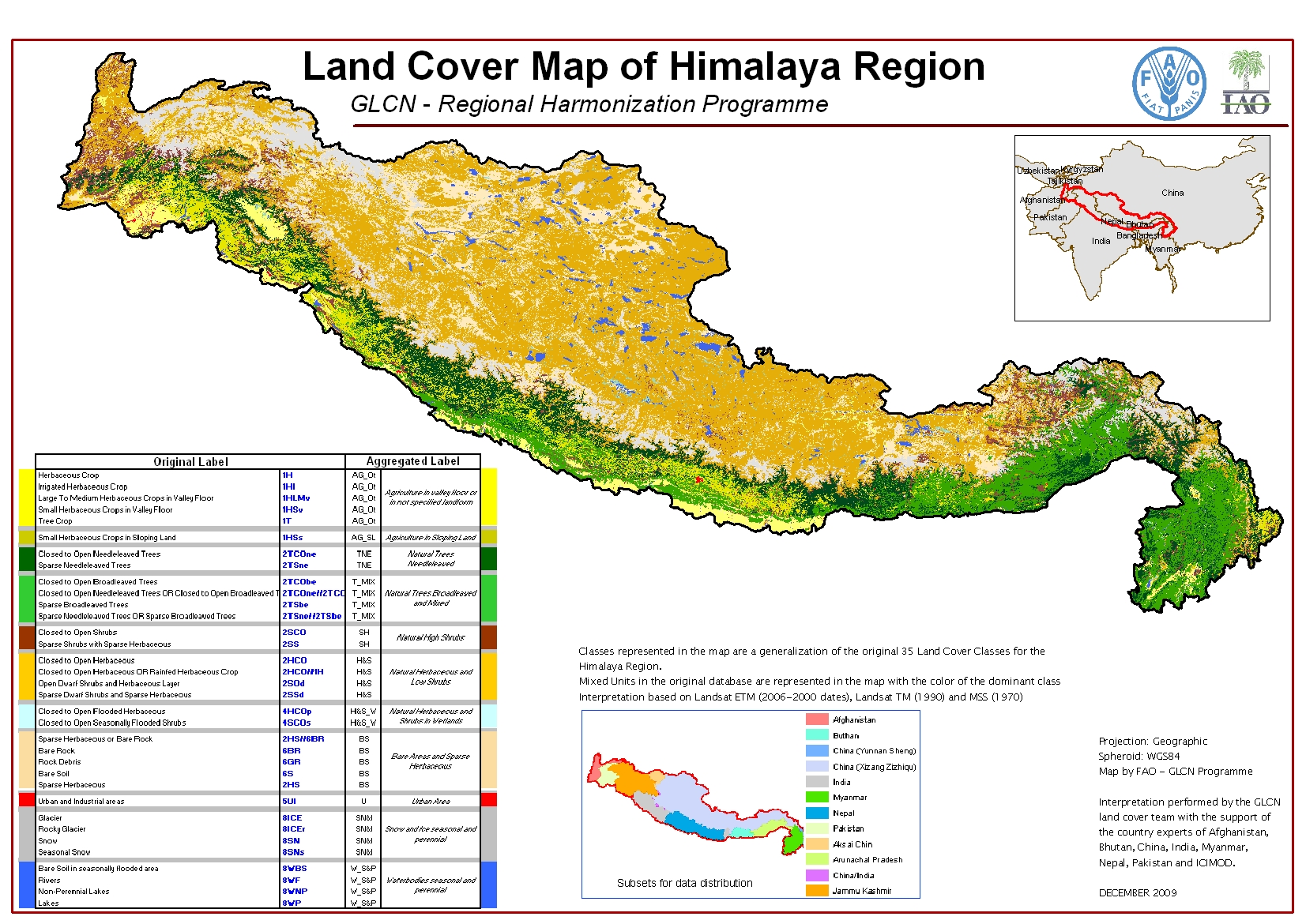
Land Cover of Himalaya Region
The Himalaya Regional Land Cover database has been produced as part of the Global Land Cover Network - Regional Harmonization Programme. Its extent includes the Hindu Kush - Karakorum - Himalaya mountain chain, which is the widest and most recent in the world.
The database was developed using 2000 Landsat satellite imagery as reference source for an automatic segmentation. The land cover change was then assessed upon other sets of historical imagery: 1970-80, 1990, and 2007. The mapping area covers about 1,500,000 km2, intersecting 6 different UTM zones. It includes portions of the following 5 countries: Afghanistan, Pakistan, India, China and Myanmar. Nepal and Bhutan are fully mapped. Aim of the programme is harmonize the regional land cover database which will allow national institutions and Governments to conduct assessment and monitoring of the land cover dynamics for environmental analysis and planning.
The Himalaya land cover mapping was performed at 1:350,000 scale and derives from a combination of visual and automatic interpretation of recent Landsat ETM satellite imageries. For this purpose, the FAO’s MADCAT software was adopted, in order to perform automatic classification. FAO’s GeoVIS interpretation software was also used. The land cover legend, consisting of 35 classes, was set up using the FAO LCCS methodology, a standardized a priori land cover classifications system applied with success in a series of FAO projects. As result, 511,292 polygons were delineated. To refine the interpretation, high resolution images from Google Earth were used.
The tabular attributes contains 14 fields with the following meaning:
Z007CODE: GIS code of the class. Z007USLB: User label updated with the 2004/2007 images.
Z007PERC: Percentage of the class. In case of a single unit the percentage is 100%; in case of mixed unit the percentage is 60/40, meaning that the first term of the mixed unit covers 60% of the polygon’s area while the second term of the mixed unit covers the 40%.
HECTARES: Area of the polygon in Hectares. The calculation was made in UTM projection (WGS84), according to the UTM Zone indicated in the field “Zone”.
AREA: Area of the polygon in square meters. The calculation was made in UTM projection (WGS84), according to the UTM Zone indicated in the field “Zone”.
AGG: Aggregated code used for the Map layout. The aggregation criteria is shown in the attached file “Conversion table for the map_35cl”.
ZONE: The UTM zone where the polygon falls.
CODE1: The user label either as single unit or as first term of a mixed unit.
CODE2: The user label as second term of a mixed unit, when present.
BOOLEAN1: The LCCS Boolean formula of Code 1, giving its representation as land cover objects.
BOOLEAN2: The LCCS Boolean formula of Code 2, giving its representation as land cover objects.
LCCSMAIN1: The LCCS main group containing Code1.
LCCSMAIN2: The LCCS main group containing Code2.
AUTO_ID: The unique number identifying each polygon. Notice that from the fields “Boolean1”, “Boolean2”, “LCCSMain1”, “LCCSMain2” is possible to derive the objects making up the land cover class covering the polygon(s) wanted.
Simple
- Date ( Publication )
- 2010-04-29T00:00:00
- Edition
- First
- Presentation form
- Digital map
- Purpose
- The purpose of the land cover database is to provide essential basic information natural resource assessment and management, environmental modelling, and decision-making and policy formulation for a sustainable land management. The strategy adopted combines the need to develop new tools and methodologies for land cover mapping with the necessity to strengthen the capacity of developing countries to produce, manage and distribute spatial information on environmental resources.
- Status
- On going
- Keywords ( Theme )
-
- landcover
- environment
- natural resources
- agriculture
- forest
- rangeland
- management
- GLCN
- land cover
- Keywords ( Place )
-
- Himalaya Region
- Use limitation
- Data is VALIDATED only at regional scale.
- Access constraints
- Restricted
- Use constraints
- Restricted
- Other constraints
- The designations employed and the presentation of material in this information product do not imply the expression of any opinion whatsoever on the part of the Food and Agriculture Organization of the United Nations (FAO) concerning the legal or development status of any country, territory, city or area or of its authorities, or concerning the delimitation of its frontiers or boundaries.
- Other constraints
- FAO declines all responsibility for errors or deficiencies in the database or software or in the documentation accompanying it, for program maintenance and upgrading as well as for any damage that may arise from them. FAO also declines any responsibility for updating the data and assumes no responsibility for errors and omissions in the data provided. Users are, however, kindly asked to report any errors or deficiencies in this product to FAO.
- Spatial representation type
- Vector
- Denominator
- 350000
- Metadata language
- eng
- Character set
- UTF8
- Topic category
-
- Imagery base maps earth cover
- Environment
- Begin date
- 2005-01-01
- End date
- 2007-12-31
))
- Supplemental Information
- The land cover was interpreted from LANDSAT imagery acquired mainly in the period 2000-2005. Current validation was made from ancillary data and free high resolution historical imagery. The field work verification it is planned shortly. Countries involved in the mapping are going to control the classes created/interpretation performed and update the database with new classes according to a more detailed interpretation scale (1:100 000).
- Reference system identifier
- WGS 1984
- Distribution format
-
-
ESRI Shapefile
(
1.0
)
-
ESRI Shapefile
(
1.0
)
- OnLine resource
-
hima_lc_afg.zip
(
WWW:LINK-1.0-http--link
)
Data for download (66.6 MB): LC Afghanistan
- OnLine resource
-
hima_lc_btn.zip
(
WWW:LINK-1.0-http--link
)
Data for download (35 MB): LC Bhutan
- OnLine resource
-
hima_lc_chn1.zip
(
WWW:LINK-1.0-http--link
)
Data for download (15 MB): LC China-Yunnan Sheng
- OnLine resource
-
hima_lc_chn3.zip
(
WWW:LINK-1.0-http--link
)
Data for download (560 MB): LC China-Xizang Zizhiqu
- OnLine resource
-
hima_lc_ind1.zip
(
WWW:LINK-1.0-http--link
)
Data for download (122 MB): LC India
- OnLine resource
-
hima_lc_npl.zip
(
WWW:LINK-1.0-http--link
)
Data for download (156 MB): LC Nepal
- OnLine resource
-
hima_lc_pak.zip
(
WWW:LINK-1.0-http--link
)
Data for download (73 MB): LC Pakistan
- OnLine resource
-
hima_lc_chn2.zip
(
WWW:LINK-1.0-http--link
)
Data for download (20 MB): LC Aksai Chin
- OnLine resource
-
hima_lc_ind3.zip
(
WWW:LINK-1.0-http--link
)
Data for download (51 MB): LC Arunachal Pradesh
- OnLine resource
-
hima_lc_chn-ind.zip
(
WWW:LINK-1.0-http--link
)
Data for download (4 MB): LC China/India
- OnLine resource
-
hima_lc_ind2.zip
(
WWW:LINK-1.0-http--link
)
Data for download (176 MB): LC Jammu Kashmir
- OnLine resource
-
hima_lc_mmr.zip
(
WWW:LINK-1.0-http--link
)
Data for download (75 MB): LC Myanmar
- OnLine resource
-
hima_change_dd.zip
(
WWW:LINK-1.0-http--link
)
Data for download (2.1 MB): LC Change Himalaya Region
- OnLine resource
-
hima_bnds_dd.zip
(
WWW:LINK-1.0-http--link
)
Data for download (1.4 MB): Boundaries Himalaya Region
- OnLine resource
-
hima_lc_legend.zip
(
WWW:LINK-1.0-http--link
)
LCCS legend
- OnLine resource
-
Geovis
(
WWW:LINK-1.0-http--link
)
ADG software (Advanced Database Gateway)
- Hierarchy level
- Dataset
- Statement
- This data set is VALIDATED only for a regional scale, even though it is cut at administrative boundaries for its distribution. It is recommended to open the data sets inside the Advanced Database Gateway (by FAO), to benefit from the "OBJECT ORIENTED" way to interact with the data base.
gmd:MD_Metadata
- File identifier
- 46d3c2ef-72c3-4f96-8e32-40723cd1847b XML
- Metadata language
- eng
- Character set
- UTF8
- Date stamp
- 2023-02-02T12:40:44
- Metadata standard name
- ISO 19115:2003/19139
- Metadata standard version
- 1.0
Overviews
Spatial extent
Provided by
