 FAO Map Catalog
climatologyMeteorologyAtmosphere
Type of resources
Available actions
Topics
Keywords
Contact for the resource
Provided by
Years
Formats
Representation types
Update frequencies
status
Scale
Resolution
-
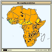
Mean monthly gridded values for precipitation in Africa. Data obtained from the Centre for Resource and Environmental Studies (CRES) at the Australian National University.
-

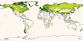
Mean wind speed at a height of 10 metres above the surface over the period 00h-24h local time. Unit: m s-1. The Wind Speed variable is part of the Agrometeorological indicators dataset produced by the European Centre for Medium-Range Weather Forecasts (ECMWF) through the Copernicus Climate Change Service (C3S). The Agrometeorological indicators dataset provides daily surface meteorological data for the period from 1979 to present as input for agriculture and agro-ecological studies. This dataset is based on the hourly ECMWF ERA5 data at surface level and is referred to as AgERA5. References: https://doi.org/10.24381/cds.6c68c9bb The Copernicus Climate Change Service (C3S) aims to combine observations of the climate system with the latest science to develop authoritative, quality-assured information about the past, current and future states of the climate in Europe and worldwide. ECMWF operates the Copernicus Climate Change Service on behalf of the European Union and will bring together expertise from across Europe to deliver the service.
-
The Food and Agriculture Organization of the United Nations (FAO) with the collaboration of the International Institute for Applied Systems Analysis (IIASA), has developed a system that enables rational land-use planning on the basis of an inventory of land resources and evaluation of biophysical limitations and potentials. This is referred to as the Agro-ecological Zones (AEZ) methodology.
-

The correlation coefficients between yield and other factors have been computed at the zone level for the period 1981-2050 and classified in 5 classes. These correlations allow identifying the causes of a negative or positive impact of climate on maize's yield. This data set has been produced in the framework of the “Climate change predictions in Sub-Saharan Africa: impacts and adaptations (ClimAfrica)” project, Work Package 4 (WP4). More information on ClimAfrica project is provided in the Supplemental Information section of this metadata.
-

The Food and Agriculture Organization of the United Nations (FAO) with the collaboration of the International Institute for Applied Systems Analysis (IIASA), has developed a system that enables rational land-use planning on the basis of an inventory of land resources and evaluation of biophysical limitations and potentials. This is referred to as the Agro-ecological Zones (AEZ) methodology.
-
Agro-climatic map of Sulawesi
-

Relative humidity at 06h (local time) at a height of 2 metres above the surface. This variable describes the amount of water vapour present in air expressed as a percentage of the amount needed for saturation at the same temperature. Unit: %. The Relative humidity variable is part of the Agrometeorological indicators dataset produced by the European Centre for Medium-Range Weather Forecasts (ECMWF) through the Copernicus Climate Change Service (C3S). The Agrometeorological indicators dataset provides daily surface meteorological data for the period from 1979 to present as input for agriculture and agro-ecological studies. This dataset is based on the hourly ECMWF ERA5 data at surface level and is referred to as AgERA5. References: https://doi.org/10.24381/cds.6c68c9bb The Copernicus Climate Change Service (C3S) aims to combine observations of the climate system with the latest science to develop authoritative, quality-assured information about the past, current and future states of the climate in Europe and worldwide. ECMWF operates the Copernicus Climate Change Service on behalf of the European Union and will bring together expertise from across Europe to deliver the service.
-
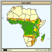
Spatial distribution of annual precipitation interpreted as rainfall runoff to fill fish ponds. Mean annual precipitation data for Africa were obtained from UNEP/GRID in Nairobi and was developed for the Global Assessment of Soil Degradation (GLASOD) using data from 1951-1980.
-
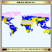
Aridity index (P/Pet) derived from IDRISI file with continuous data, reclassified into 6 classes (+ water bodies); The 6th class indicates cold climate derived from Thermal climates (Boreal and Arctic) received from IIASA in 2002. The IDRISI file with Aridity values was received by IIASA on February 2003.
-
Coverage: Indonesia, Malaysia