 FAO Map Catalog
FAO-UN - Land and Water Division (CBL)
Type of resources
Available actions
Topics
Keywords
Contact for the resource
Provided by
Years
Representation types
Update frequencies
status
Scale
-
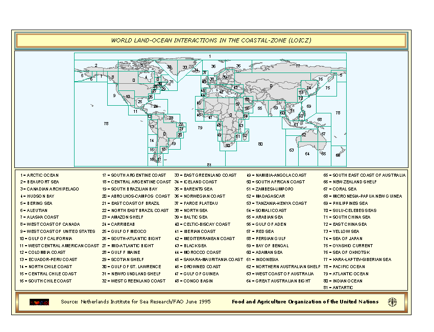
World Land-Ocean Interactions in the Coastal-Zone based on a Coastal zone (LOICZ)database received in 1995 from the Netherlands Institute for Sea Research (NIOZ).
-
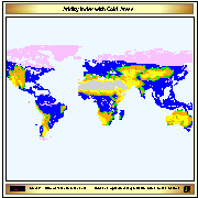
Aridity index (P/Pet) derived from IDRISI file with continuous data, reclassified into 6 classes (+ water bodies); The 6th class indicates cold climate derived from Thermal climates (Boreal and Arctic) received from IIASA in 2002. The IDRISI file with Aridity values was received by IIASA on February 2003.
-
The updating of world soil resources, using the Soil and Terrain (SOTER) digital database methodology, is part of a global SOTER programme and intended to replace the FAO/Unesco 1:5 million scale Soil Map of the World (1971-1981). The original map sheets were published in 1970-1980 and were compiled on basis of information and data available at that time. It is understandable that a substantial part does not reflect the present state of knowledge of the soils in the regions. The national institutes, responsible for the natural resources inventories, have been collecting a wealth of new information on the distribution and occurrence of soils in their region, which has resulted in updating their national soil maps mostly at scale 1:1 million, often applying the Revised Legend (FAO, UNEP, ISRIC, 1988) for the description of the mapping units. The International Union of Soil Science (IUSS) adopted an important change in the classification used for the map by introducing lower levels of subunits of the World Reference Base for Soil Resources (IUSS, FAO, ISRIC, 1998). This, together with the new soil data available at national level, justified such an update of the soil resources for the regional updates (South America and the Caribbean, Northeastern Africa, Southern Africa, East and Central Europe, North and Central Eurasia and Central Africa have been completed to date.
-
The Soil and Terrain Database Map of East Africa is a computer system for the storage, display, interpretation and analysis of the Soil Map of East Africa at scale 1:1.000.000. The system consists of the soil and terrain database with corresponding soil maps, that are accessed by the programme for visualization in different viewer formats. Various interactive querying and selection tools provide easy access to specific parts of the database for display as thematic map, data browser or data entry form.
-

The map illustrates an analysis carried out within the FAO-GLADIS framework. The analysis considers the changes in the provisioning capacity of ecosystems matched with an analysis of impacts on people. This analysis, conducted in GLADIS, uses degradation trends linked to poverty levels of the population affected (LDI*Poverty class*Population, excluding low poverty regions). The map is in the SOLAW Report 6 - Land Degradation.
-
Simplified version of the FAO/UNESCO soil map of the world, containing only 8 major soil classes. The map has been used to do the back cover of the publication GIS in FAO (FAO, Feb 89)
-

The Soil and Terrain Database Map of East Africa is a computer system for the storage, display, interpretation and analysis of the Soil Map of East Africa at scale 1:1.000.000. The system consists of the soil and terrain database with corresponding soil maps, that are accessed by the programme for visualization in different viewer formats. Various interactive querying and selection tools provide easy access to specific parts of the database for display as thematic map, data browser or data entry form.
-
Estimate of food self suffficieny based on population density and expressed in terms of the number of kilograms per person.The map also includes protected areas.
-

The Soil and Terrain Database Map of East Africa is a computer system for the storage, display, interpretation and analysis of the Soil Map of East Africa at scale 1:1.000.000. The system consists of the soil and terrain database with corresponding soil maps, that are accessed by the programme for visualization in different viewer formats. Various interactive querying and selection tools provide easy access to specific parts of the database for display as thematic map, data browser or data entry form.