 FAO Map Catalog
FAO-UN - Climate and Environment Division (CBC)
Type of resources
Available actions
Topics
Keywords
Contact for the resource
Provided by
Years
Representation types
Update frequencies
status
Scale
-
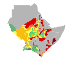
Maize yield in Djibouti, Eritrea, Ethiopia, Kenya, Somalia, Sudan and Uganda. Map presents reference yield estimated through data collection and agricultural statistics.
-
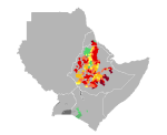
Wheat yield in Djibouti, Eritrea, Ethiopia, Kenya, Somalia, Sudan and Uganda. Map presents reference yield estimated through data collection and agricultural statistics.
-
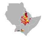
Barley yield in Djibouti, Eritrea, Ethiopia, Kenya, Somalia, Sudan and Uganda. Map presents reference yield estimated through data collection and agricultural statistics.
-
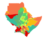
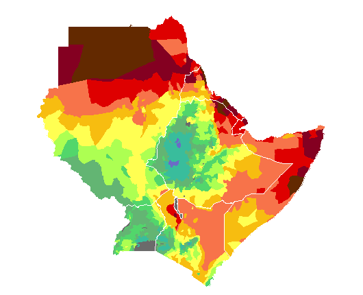
Inherent soil fertility class in Djibouti, Eritrea, Ethiopia, Kenya, Somalia, Sudan and Uganda.
-
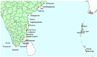
The images provide detailed rainfed crop calendar information for coastal areas in India affected by the Tsunami, for the following stations: Vishakhapatnam, Kakinda, Nellore, Cuddalore, Trivandrum, Port blair, Srikakulam, Tuni, Kottapatnam, Dugarajupatnam, Chennai, Pondicherry, Karaikal, Vederanniyam, Rameswaram, Kilakarai, Tuticorin Kolachel, Quilon, Manglutan, Karen, Tafwap, Bananga.
-
The images provide detailed rainfed crop calendar information for coastal areas in Malaysia affected by the Tsunami, for the following stations: Alor setar, Kuah, George town.
-
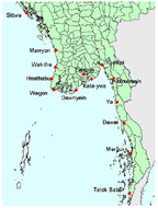
The images provide detailed rainfed crop calendar information for coastal areas in Myanmar affected by the Tsunami, for the following stations: Mergui, Dawei, Moulmein, Sittwe, Talok babai, Ye, Yangon, Kyaikpi, Kala-ywa, Dawnyein, Wagon, Hnathabu, Wet-the, Mawyon.
-
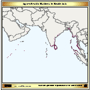
The layer provides the agro-climatic stations located on the Asian coastal areas affected by the Tsunami.
-
Average annual rainfall in Djibouti, Eritrea, Ethiopia, Kenya, Somalia, Sudan and Uganda.
-
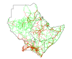
Roads in Djibouti, Eritrea, Ethiopia, Kenya, Somalia, Sudan and Uganda.