 FAO Map Catalog
FAO- GeoNetwork
Type of resources
Available actions
Topics
Keywords
Contact for the resource
Provided by
Years
Representation types
Update frequencies
status
Scale
-
"Seamless" set of 3304 Arc-grid based DEM tiles derived from the Version 2 of the SRTM 3 arc second data library covering Africa; nominal 90 metre. Source: NASA/SRTM
-
Derivative of the above "Null" SRTM 3-arc second dataset with terrestrial void areas backfilled with SRTM-GTopo30 DEM, 3204 Arc-Grid tiles. Source: FAO
-

Arc-grid "2.5d Hillshade" based derivative of SRTM 3-arc second "Null"set covering Africa, 3204 tiles. Source: FAO
-
Derivative of the "Baseline" SRTM 3 arc second dataset with ocean and terrestrial void areas set to null using a SRTM-SWBD 1 arc second mask, 3204 Arc-grid based tiles. Source: FAO
-
1:750 000 scale seamless base map of continental Africa based on VMap0-Ed3, DCW, and Classified GTopo30 DEM. VMAP0 is Vector Map for Level 0; DCW is Digital Chart of the Word; DEM is Digital Elevation Model.. The VRTL_MAP image data layer is comprised of 51784x51084 derivative image virtual base map features derived based on 1:750 000 data originally from FAO.
-

Robust derivative of VMap0 - Ed5 data layers with harmonized encoding. The HYPSO_PT shapefile data layer is comprised of 80449 derivative vector framework library features derived based on 1:1 000 000 data originally from VMap0, 5th Edition. The layer provides nominal analytical/mapping at 1:1 000 000. Data processing 75% complete globally, with African subset 100% complete. Acronyms and Abbreviations: VMap0 - Vector Map for Level 0.
-

Ad1-Linear coastlines, national and other areas of sovereignty boundaries compiled from multiple RWDB2 source layers, circa 1997. The RWDB_AD1-LN shapefile data layer is comprised of 18870 derivative vector framework library features derived based on 1:3 000 000 data originally from RWDBII. The layer provides nominal analytical/mapping at 1:3 000 000. Data processing complete globally. Acronyms and Abbreviations: RWDB2 or RWDB II- Relational World Database II.
-
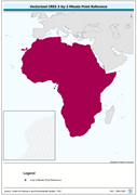
Vectorized CRES 3-by-3 Minute Point Reference. The CRES_PT shapefile data layer is comprised of 1004351 derivative calculated water temperature features derived based on 0.5 degrees resolution data originally from CRES/FAO. The layer provides nominal analytical/mapping at 1:220 000 000. Acronyms and Abbreviations: CRES - Centre for Resource and Environmental Studies, The Australian National University (ANU).
-
A dissolved version of the AVec_DBC data using ArcView to ensure any summary SWB or watershed statistical data are not double counted. The VMAP_SUM_AD1 shapefile data layer is comprised of 64 derivative polygon surface water bodies by admin units features derived based on 1:1 000 000 data originally from VMap0. The layer provides nominal analytical/mapping at 1:1 000 000. Acronyms and Abbreviations: VMap0 - Vector Map for Level 0; SWB - Surface Water Body.
-
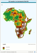
WRIA_DEM: Hydrologically filled GTopo30 DEM with the main stems of cartographic rivers "burned-in" for irrigation analysis. GT30/GTopo30 is Global Topographic 30 arc second DEM database, nominal 1km postings; DEM is Digital Elevation Model. The WRIALAEA grid data layer is comprised of 9194x8736 derivative raster hydrologically filled dem features derived based on 1 kilometer data originally from FAO.