 FAO Map Catalog
FAO - Livestock Information and Policy Branch
Type of resources
Available actions
Topics
Keywords
Contact for the resource
Provided by
Representation types
Update frequencies
status
Scale
-

The Gridded Livestock of the World (GLW) is a global livestock mapping project by the Food and Agriculture Organization's Animal Production and Health Division (FAO-AGA). It describes the global spatial distribution of cattle, buffaloes, sheep, goats, pigs and poultry. The most-detailed sub-national census data are disaggregated based on statistical relations with some environmental variables in similar agro-ecological zones.
-
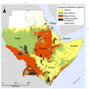
The dataset provides the distribution of pastoral, agro-pastoral and mixed farming systems in six countries of East Africa (Djibouti, Eritrea, Ethiopia, Kenya, Somalia, Sudan and Uganda). The production systems are defined according to the ratio of livestock- to crop-derived income. If L is defined as the total household income derived from livestock and C as the total household income derived from crops, then for pastoral production systems: L/C > 4; for agro-pastoral systems: 1 < L/C < 4; and for mixed farming systems L/C < 1. The map is based on datasets collected in the framework of livelihood analysis in the period 2000 and 2007. Input data were available for Djibouti, Eritrea, Kenya, Somalia, Uganda and parts of Ethiopia and Sudan. Data on these countries and regions provided the training data for the subsequent statistical analysis based on environmental and other geospatial predictors, which resulted in a full regional map. More detailed information on this datasets is available in “Geographic distribution and environmental characterization of livestock production systems in Eastern Africaâ€, 2009. Agriculture, Ecosystems & Environment, 135, 98-110.