 FAO Map Catalog
MODIS
Type of resources
Available actions
Topics
Keywords
Contact for the resource
Provided by
Years
Formats
Representation types
Update frequencies
status
Scale
Resolution
-
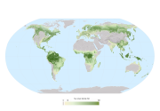
The 2015 Global Forest Resources Assessment (FRA2015) continues the tradition of seeking to describe the worldâs forests â a tradition that began in 1948. The worldâs forest 2010 map is a raster product with a pixel size of 250 meters by 250 meters. It was prepared with the following geospatial layers : - Forest cover data from the Vegetation Continuous Fields product (VCF) derived from the Moderate Resolution Imaging Spectroradiometer (MODIS) sensor, on-board the Terra and Aqua satellites (Earth Observation System, NASA) with a 250 m spatial resolution (Hansen et al., 2003). - Water data from the Shuttle Radar Topography Mission (SRTM, NASA) Water Body Data at 250 m spatial resolution in combination with the MODIS global water mask (Carroll et al., 2009). - Elevation data from the SRTM at 1 km resolution, down-sampled to the 10 million scale. - Country boundaries and coastlines from the Global Administrative Unit Layer (GAUL, 2008) of the FAO. - Global ecological zones (FAO, 2012) References: - Hansen, M., R. DeFries, J.R. Townshend, M. Carroll, C. Dimiceli, and R. Sohlberg, 2003. Vegetation Continuous Fields MOD44B, 2001 Percent Tree Cover, Collection 3, University of Maryland, College Park, Maryland, 2001. - Carroll, M., Townshend, J., DiMiceli, C., Noojipady, P., Sohlberg, R. 2009. A New Global Raster Water Mask at 250 Meter Resolution. International Journal of Digital Earth. ( volume 2 number 4) - FAO, 2012 Global ecological zones for FAO forest reporting: 2010 Update. Forest resources Assessment Working Paper 179, Rome, 2012.
-
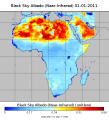
The dataset represents different MODIS Albedo's based on MCD43C3 Albedo 8-Day L3, for the African continent at 8 daily 0.5 degree spatial resolution. The resulting data set is based on the average aof all valid 0.05 degree grid cells within a half degree grid cell. List of Albedos: BSA_nir_Albedo/ [Black Sky Albedo (Near-Infrared)] BSA_shortwave_Albedo/ [Black Sky Albedo (shortwave)] BSA_vis_Albedo/ [Black Sky Albedo (visible)] WSA_nir_Albedo/ [White Sky Albedo (Near-Infrared)] WSA_shortwave_Albedo/ [White Sky Albedo (shortwave)] WSA_vis_Albedo/ [White Sky Albedo (White Sky Albedo (Visible)isible)] This data set has been produced in the framework of the "Climate change predictions in Sub-Saharan Africa: impacts and adaptations (ClimAfrica)" project, Work Package 1 (WP1). WP1 (Past climate variability) aimed to provide consolidated data to other WPs in ClimAfrica, and to analyze the interactions between climate variability, water availability and ecosystem productivity of Sub-Saharan Africa. Various data streams that diagnose the variability of the climate, in particular the water cycle, and the productivity of ecosystems in the past decades, have been collected, analyzed and synthesized. The data streams range from ground-based observations and satellite remote sensing to model simulations. More information on ClimAfrica project is provided in the Supplemental Information section of this metadata.
-
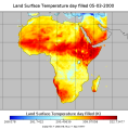
The dataset covers Land Surface Temperature (Day and Night) based on the MOD11C2 climate modelling grid (CMG). The resulting product is the average of all 0.05 degree grid cells, within a 0.5 degree grid cell. This data set has been produced in the framework of the "Climate change predictions in Sub-Saharan Africa: impacts and adaptations (ClimAfrica)" project, Work Package 1 (WP1). WP1 (Past climate variability) aimed to provide consolidated data to other WPs in ClimAfrica, and to analyze the interactions between climate variability, water availability and ecosystem productivity of Sub-Saharan Africa. Various data streams that diagnose the variability of the climate, in particular the water cycle, and the productivity of ecosystems in the past decades, have been collected, analyzed and synthesized. The data streams range from ground-based observations and satellite remote sensing to model simulations. More information on ClimAfrica project is provided in the Supplemental Information section of this metadata.