 FAO Map Catalog
Geoscientific information
Type of resources
Available actions
Topics
Keywords
Contact for the resource
Provided by
Years
Formats
Representation types
Update frequencies
status
Scale
Resolution
-
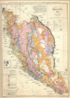
Geological map of Malaya (300 000)
-
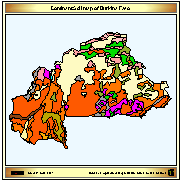
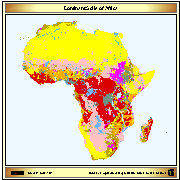
Dominant soil map of Burkina Faso derived from the Digital Soil Map of the World.
-
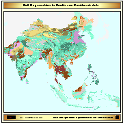
ASSOD (1997) is a follow-up activity of GLASOD. The same methodology was used at a more detailed scale (1:5M) for South and Southeast Asia. The GLASOD methodology was slightly refined. © ISRIC,FAO,UNEP, 1997
-
Grid with estimated easily available soil moisture in mm/m with a spatial resolution of 5 * 5 arc minutes. Information with regard to easily available soil moisture was calculated from the "Derived Soil Properties" of the "Digital Soil Map of the World" which contains raster information on soil moisture in different classes.
-
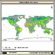
Simplified version of the FAO/UNESCO soil map of the world, containing only 8 major soil classes. The map has been used to do the back cover of the publication GIS in FAO (FAO, Feb 89)
-

Include: Carte des opérations dressée par le projet d''étude des eaux souterraines au Liban en mars 1968, Carte pluviométrique (1 000 000), Carte des ressources potentielles (1 000 000),
-
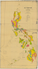
Include: Soil Erosion Map of the Philippines (1 000 000)
-
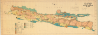
Include: Peta Geologi (Djawa Dan Madura) â Menurut Verbeek dan Fennema (1 000 000)
-

Land Use Map of the Philippines (1 000 000)
-

Include: Generalized salinity map of Punjab and Sind