 FAO Map Catalog
Creation year
15-1
Type of resources
Available actions
Topics
Keywords
Contact for the resource
Provided by
Years
Representation types
Update frequencies
status
Scale
From
1
-
1
/
1
-
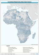
Seamless and topologically robust derivative of source VMap0 - 5th Edition Rivers integrated with SWB (Surface Waterbody) linear outlines and limited number of dam, canal and other features where available from source library layers. The VMAP_RIV shapefile data layer is comprised of 173504 derivative vector rivers and major surface water bodies features derived based on 1:1 000 000 data originally from VMap0/ DCW. The layer provides nominal analytical/mapping at 1:1 000 000. Seamlessly complete globally, with consolidation-harmonization @ ~70%, this Africa subset at final. Acronyms and Abbreviations: VMap0 - Vector Map for Level 0; DCW - Digital Chart of the World.