 FAO Map Catalog
12-0
Type of resources
Available actions
Topics
Keywords
Contact for the resource
Provided by
Years
Representation types
Update frequencies
status
Scale
-
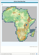
1:750 000 scale seamless base map of continental Africa based on VMap0-Ed3, DCW, and Classified GTopo30 DEM. VMAP0 is Vector Map for Level 0; DCW is Digital Chart of the Word; DEM is Digital Elevation Model.. The VRTL_MAP image data layer is comprised of 51784x51084 derivative image virtual base map features derived based on 1:750 000 data originally from FAO.
-
Catalog of Arc-Grid based derivaitive of SRTM 3-arc second Version 2 DEM for Africa, seamless baseline of 3 204 1x1 overlapping tiles. SRTM is Shuttle Radar Topography Mission; DEM is Digital Elevation Model. The SRTM-3AS_IMGCAT_BASE Image data layer is comprised of 3204 derivative calculated seamless image catalog features derived based on 0.000833_ data originally from FAO.
-
Catalog of Arc-Grid based derivaitive of SRTM 3-arc second Version 2 DEM for Africa, seamless tiled compilation with ocean and terrestrial void areas set to null SRTM-SWBD 1-arc second mask. SRTM is Shuttle Radar Topography Mission; DEM is Digital Elevation Model. The SRTM-3AS_IMGCAT_NULL Image data layer is comprised of 3204 derivative calculated seamless image catalog features derived based on 0.000833_ data originally from FAO.
-
Catalog of Arc-Grid based derivaitive of SRTM 3-arc second Version 2 DEM for Africa, seamless tiled compilation with oceans set to null using SRTM-SWBD 1-arc second mask and and terrestrial void areas backfilled with SRTM-GTopo30 DEM. SRTM is Shuttle Radar Topography Mission; DEM is Digital Elevation Model; GTopo30 is Global Topographic 30 arc second DEM database, nominal 1km postings. The SRTM-3AS_IMGCAT_FILLED Image data layer is comprised of 3204 derivative calculated seamless image catalog features derived based on 0.000833_ data originally from FAO.