 FAO Map Catalog
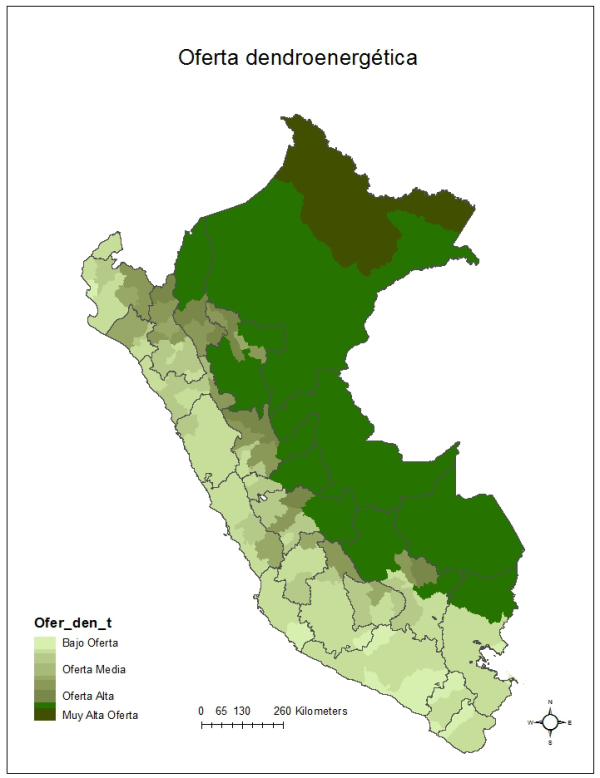
Woodfuel supply, changes by scenario and type of demand in Peru
This map shows that forest biomass is unevenly distributed the Peruvian territory. This heterogeneous distribution of resources is the result of geographical and climatic variability that characterizes this country. The forest ecosystem has the largest amount of forest biomass available, while the coastal area and the mountains in the south have limited supply of biomass. This uneven distribution is the result of the tropical humid climate of the jungle, the desert climate in the coast and the limited availability of water in the southern highlands. This distribution of forest biomass, its relationship with the weather, the population distribution in the country and poverty, deserve studies locally. It is noted that the southern highlands is the part with most poverty in the country and is known as the Andean trapeze. The region with the largest supply of biomass is Loreto 145 Mt per year, other regions such as Amazonas, Cusco and San Martin have about 10 Mt per year. While regions that have a limited supply of woody biomass are: Arequipa, Moquegua and Tacna 15 000 17 700 and 14 000 Mt per annum respectively.
Source data:
- Dirección General Forestal de Faura Silvestre (DGFF). 2009. Perú forestal en números, ano 2008. Ministerio de Agricultura-DGFF. Lima.
- INRENA. 2005. Mapa Forestal del Perú 2000. (No public).
- INEI, 2008. Perfil socioeconómico del Perú. 2da. Edición. Census Nacionales 2007. XI de población y VI de vivienda. Lima.
This dataset is part of the result of the Bioenergy and Food Security (BEFS) analysis for Perú on land and agro-climatic suitability and availability for crops. All BEFS results have been reported in the FAO publication “Bioenergía y seguridad alimentaria - El análisis de BEFS para el Perú - Compendio técnico Vol I y II†and the final products made available in this catalogue.
Simple
- Date ( Publication )
- Presentation form
- Digital map
- Purpose
- Land suitability assessment for cultivation of bio-energy crops.
- Status
- Completed
- Maintenance and update frequency
- As needed
- Keywords ( Theme )
-
- BEFS
- agriculture
- bioenergy
- biomass
- food security
- woodfuel
- residues
- rural development
- wood energy supply
- Tag_BEFS
- Keywords ( Place )
-
- Peru
- Access constraints
- Copyright
- Spatial representation type
- Vector
- Metadata language
- en
- Character set
- UTF8
- Topic category
-
- Farming
))
- Reference system identifier
- EPSG:4326 (WGS1984)
- Number of dimensions
- 3
- Dimension name
- Row
- Dimension name
- Column
- Dimension name
- Vertical
- Cell geometry
- Area
- Transformation parameter availability
- No
- OnLine resource
-
Bioenergy and Food Security (BEFS) website
(
WWW:LINK-1.0-http--link
)
Bioenergy and Food Security (BEFS) website
- OnLine resource
-
Bioenergía y seguridad alimentaria - El análisis de BEFS para el Perú - Compendio Técnico Vol I
(
WWW:LINK-1.0-http--link
)
Bioenergía y seguridad alimentaria - El análisis de BEFS para el Perú - Compendio Técnico Vol I
- OnLine resource
-
Bioenergía y seguridad alimentaria - El análisis de BEFS para el Perú - Compendio Técnico Vol II
(
WWW:LINK-1.0-http--link
)
Bioenergía y seguridad alimentaria - El análisis de BEFS para el Perú - Compendio Técnico Vol II
- OnLine resource
-
resultados_ll_54465.zip
(
WWW:DOWNLOAD-1.0-http--download
)
Woodfuel supply, changes by scenario and type of demand
- OnLine resource
-
resultados_ll_54465
(
OGC:WMS
)
Woodfuel supply, changes by scenario and type of demand
- Hierarchy level
- Dataset
gmd:MD_Metadata
- File identifier
- e18be52d-14ad-4f60-80f3-3c86b7316df1 XML
- Metadata language
- en
- Character set
- UTF8
- Date stamp
- 2020-04-09T13:03:53
- Metadata standard name
- ISO 19115:2003/19139
- Metadata standard version
- 1.0
Overviews

Spatial extent
Provided by
