 FAO Map Catalog
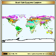
Olson's World Ecosystem Complexes Map
Vector map based on a Digital Raster Data 10-minute Cartesian Orthonormal Geodetic 1080x2160 grid.
Source: Global Ecosystems Map by J. S. Olson 1992 (Global Patterns Company)
Olson, J.S. 1992. World Ecosystems (WE1.4). Digital Raster Data on a 10-minute Cartesian Orthonormal Geodetic 1080x2160 grid. More information on the source at https://www.ngdc.noaa.gov/ecosys/cdroms/AVHRR97_d2/document/ncillary/owe/aareadme.htm
Simple
- Date ( Creation )
- 1992-05-01
- Date ( Revision )
- 2002-05-31
- Edition
- First edition
- Presentation form
- Digital map
- Purpose
- Ecological Classification.
- Status
- On going
- Keywords
-
- Biogeography
- Keywords ( Theme )
-
- Forest ecology
- Ecoregions
- Olson
- Keywords ( Place )
-
- World
- Access constraints
- Copyright
- Use constraints
- Copyright
- Spatial representation type
- Vector
- Metadata language
- eng
- Character set
- UTF8
- Topic category
-
- Biota
))
- Begin date
- 1992-05-01
- Distribution format
-
-
ESRI Shapefile
(
1.0
)
-
ESRI Shapefile
(
1.0
)
- OnLine resource
-
geonetwork:olson_1007
(
OGC:WMS-1.1.1-http-get-map
)
Olson's World Ecosystem Complexes Map
- OnLine resource
-
olson.zip
(
WWW:DOWNLOAD-1.0-http--download
)
Olson's World Ecosystem Complexes (SHP)
- OnLine resource
-
National Centers for Environmental Information
(
WWW:LINK-1.0-http--link
)
National Centers for Environmental Information
- OnLine resource
-
Documentation on Olson's World Ecosystems published in the Global Ecosystems Database
(
WWW:LINK-1.0-http--link
)
Documentation on Olson's World Ecosystems published in the Global Ecosystems Database
gmd:MD_Metadata
- File identifier
- be34dd90-88fd-11da-a88f-000d939bc5d8 XML
- Metadata language
- eng
- Character set
- UTF8
- Date stamp
- 2022-02-02T09:56:50
- Metadata standard name
- ISO 19115:2003/19139
- Metadata standard version
- 1.0
Overviews
Spatial extent
Provided by
