 FAO Map Catalog
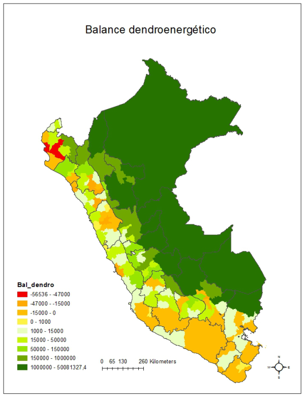
Dendroenergetic balance in Peru
The balance between wood energy supply and demand indicates that Peru has a positive balance of 250 million metric tons a year, but for the variety of its geography and climate, the distribution of this surplus is not uniform. This map shows that there are provinces located in the jungle with high surplus, while other provinces of the coastal and mountains ecosystems have serious deficits.
Of all the provinces of Peru (194), there are 56 that have deficit in this balance. The deficits range from 56 536 t in the province of Piura and almost 47 000 t per year of Paita to 610 t per year of Pomabamba. The deficit is concentrated mainly in the provinces outside the coast and mountains of Arequipa, Ica, Callao and Tacna regions.
Other provinces have balances close to 0, (consider up to 30 000 tonnes a year) also located in the coast and mountains of Ancash, Apurimac, Ayacucho, Cusco, La Libertad, Tumbes and Lima, among others regions.
On the surplus side, peak values are located in the provinces belonging to the Loreto region, with values in excess of 8 Mt per year, with a maximum of 50 Mt per year in the province of Maynas. Other provinces with large surpluses are The Convention (Cusco) with values close to 8 Mt per year, Tambopata (Madre de Dios) with over 11 Mt and Oxapampa (Pasco) with values of 4 Mt per year.
Source data:
- Dirección General Forestal de Faura Silvestre (DGFF). 2009. Perú forestal en números, ano 2008. Ministerio de Agricultura-DGFF. Lima.
- INEI, 2008. Perfil socioeconómico del Perú. 2da. Edición. Census Nacionales 2007. XI de población y VI de vivienda. Lima.
This dataset is part of the result of the Bioenergy and Food Security (BEFS) analysis for Perú on land and agro-climatic suitability and availability for crops. All BEFS results have been reported in the FAO publication “Bioenergía y seguridad alimentaria - El análisis de BEFS para el Perú - Compendio técnico Vol I y II†and the final products made available in this catalogue.
Simple
- Date ( Publication )
- Presentation form
- Digital map
- Status
- Completed
- Maintenance and update frequency
- As needed
- Keywords ( Theme )
-
- BEFS
- agriculture
- bioenergy
- biomass
- conservation agriculture
- ethanol
- food security
- land suitability
- land suitability index
- residues
- rural development
- dendroenergetic balance
- Tag_BEFS
- Keywords ( Place )
-
- Peru
- Access constraints
- Copyright
- Spatial representation type
- Vector
- Metadata language
- en
- Character set
- UTF8
- Topic category
-
- Farming
))
- Reference system identifier
- WGS 1984
- Number of dimensions
- 3
- Dimension name
- Row
- Dimension name
- Column
- Dimension name
- Vertical
- Cell geometry
- Area
- Transformation parameter availability
- No
- OnLine resource
-
Bioenergía y seguridad alimentaria - El análisis de BEFS para el Perú - Compendio Técnico Vol I
(
WWW:LINK-1.0-http--link
)
Bioenergía y seguridad alimentaria - El análisis de BEFS para el Perú - Compendio Técnico Vol I
- OnLine resource
-
Bioenergía y seguridad alimentaria - El análisis de BEFS para el Perú - Compendio Técnico Vol II
(
WWW:LINK-1.0-http--link
)
Bioenergía y seguridad alimentaria - El análisis de BEFS para el Perú - Compendio Técnico Vol II
- OnLine resource
-
resultados_ll_54469.zip
(
WWW:DOWNLOAD-1.0-http--download
)
Dendroenergetic balance in Peru
- OnLine resource
-
Bioenergy and Food Security (BEFS) website
(
WWW:LINK-1.0-http--link
)
Bioenergy and Food Security (BEFS) website
- OnLine resource
-
resultados_ll_54469
(
OGC:WMS
)
Dendroenergetic balance in Peru
- Hierarchy level
- Dataset
gmd:MD_Metadata
- File identifier
- 7b1b3646-aa4f-455b-8a0e-7e686d5769d8 XML
- Metadata language
- en
- Character set
- UTF8
- Date stamp
- 2020-04-09T13:04:22
- Metadata standard name
- ISO 19115:2003/19139
- Metadata standard version
- 1.0
Overviews
Spatial extent
Provided by
