 FAO Map Catalog
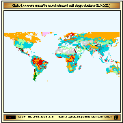
Global assesment of human induced soil degradation (GLASOD)
Digital version of the GLASOD database. The International Soil Reference and Information
Centre (ISRIC) at Wageningen ( The Netherlands) was commissioned by the United Nations Environment Programme (UNEP) to collect the GLASOD database. From the data, ISRIC
produced a 1:10 million scale wall chart which was published in 1990. One of the prime objectives of assembling the GLASOD database was its use in the Global Assessment of Desertification. Further processing was then conducted by UNEP Global Resource Information Database (GRID)
Simple
- Date ( Creation )
- 03-1995
- Edition
- first
- Presentation form
- Digital map
- Status
- Completed
- Maintenance and update frequency
- As needed
- Keywords ( Theme )
-
- Soil
- Tag_LUS
- Tag_land
- Keywords ( Place )
-
- World
- Spatial representation type
- Vector
- Denominator
- 10000000
- Metadata language
- eng
- Character set
- UTF8
- Topic category
-
- Geoscientific information
))
- Supplemental Information
- The coverage is also available in Mollweide projection.
- Reference system identifier
- WGS 1984
- OnLine resource
-
ISRIC website
(
WWW:LINK-1.0-http--link
)
ISRIC website
- OnLine resource
-
gls2.zip
(
WWW:DOWNLOAD-1.0-http--download
)
GLASOD - Shapefile format in Geographic projection
- OnLine resource
-
gls1.zip
(
WWW:DOWNLOAD-1.0-http--download
)
GLASOD - Shapefile format in Mollweide projection
- Hierarchy level
- Dataset
gmd:MD_Metadata
- File identifier
- d74026a0-88fd-11da-a88f-000d939bc5d8 XML
- Metadata language
- eng
- Character set
- UTF8
- Date stamp
- 2019-11-22T10:26:27
- Metadata standard name
- ISO 19115:2003/19139
- Metadata standard version
- 1.0
Overviews

Spatial extent
Provided by
