 FAO Map Catalog
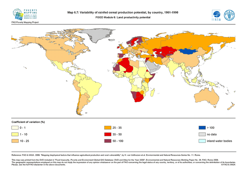
Variability of rainfed cereal production potential, by country, 1961-1990 (FGGD)
The FGGD production potential variability map is a global vector datalayer at scale 1:5 000 000. The map depicts the average coefficient of variation for cereal production potential under rainfed conditions for the period 1961 to 1990 by country. The method is described in FAO and IIASA, 2007, Mapping biophysical factors that influence agricultural production and rural vulnerability, by H. von Velthuizen et al.
Simple
- Date ( Publication )
- 2007-08-23
- Edition
- 1.0
- Presentation form
- Digital document
- Purpose
- The FGGD Digital Atlas consists of more than 100 global database that allows to analyse food insecurity and poverty in relation to the environment.
- Status
- Completed
Point of contact
FAO - GIS UNIT
-
(
GIS Manager
)
Viale delle Terme di Caracalla, 1
,
Rome
,
00153
,
Italy
- Maintenance and update frequency
- As needed
- Keywords ( Theme )
-
- cereals
- crops
- rainfed areas
- Keywords ( Place )
-
- World
- Access constraints
- Copyright
- Use constraints
- Copyright
- Spatial representation type
- Vector
- Denominator
- 5000000
- Metadata language
- eng
- Character set
- UTF8
- Topic category
-
- Farming
N
S
E
W
))
- Supplemental Information
- This dataset is contained in Module 6 "Land productivity potential" of Food Insecurity, Poverty and Environment Global GIS Database (FGGD) (FAO, 2007).
- Reference system identifier
- GCS_WGS_1984
- Distribution format
-
-
TIFF
(
)
-
TIFF
(
)
- OnLine resource
-
Map6_7.zip
(
WWW:DOWNLOAD-1.0-http--download
)
Variability of rainfed cereal production potential, by country, 1961-1990 - Vector (4 Mb)
- OnLine resource
-
cereal_production_potential_1961_1990
(
OGC:WMS-1.1.1-http-get-map
)
Variability of rainfed cereal production potential, by country, 1961-1990
- OnLine resource
- Mapping biophysical factors that influence agricultural production and rural vulnerability ( WWW:LINK-1.0-http--link )
Data quality info
No information provided.
gmd:MD_Metadata
- File identifier
- 66eb9970-7bcd-11db-b9b2-000d939bc5d8 XML
- Metadata language
- eng
- Character set
- UTF8
- Date stamp
- 2023-02-03T08:42:09
- Metadata standard name
- ISO 19115:2003/19139
- Metadata standard version
- 1.0
Point of contact
FAO - GIS UNIT
-
Mirella Salvatore
(
Consultant
)
Via delle Terme di Caracalla, 1
,
Rome
,
00153
,
Italy
Overviews

thumbnail
large_thumbnail
Spatial extent
N
S
E
W
Provided by

Associated resources
Not available